
Make a donation
Greece topographic map
Click on the map to display elevation.
Make a donation
Greece
Approximately 80% of Greece consists of mountains or hills, making the country one of the most mountainous in Europe. Mount Olympus, the mythical abode of the Greek Gods, culminates at Mytikas peak 2,918 metres (9,573 ft), the highest in the country. Western Greece contains a number of lakes and wetlands and is dominated by the Pindus mountain range. The Pindus, a continuation of the Dinaric Alps, reaches a maximum elevation of 2,637 m (8,652 ft) at Mt. Smolikas (the second-highest in Greece) and historically has been a significant barrier to east–west travel. Its extensions cross through the Peloponnese, ending in the island of Crete. The Vikos Gorge, part of the Vikos-Aoos National Park in the Pindus range, is listed by the Guinness book of World Records as the deepest gorge in the world. Another notable formation are the Meteora rock pillars, atop which have been built medieval Greek Orthodox monasteries.
Make a donation
About this map
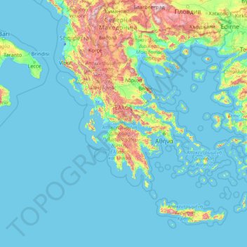
Name: Greece topographic map, elevation, terrain.
Location: Greece (34.71889 19.11275 41.74889 29.68381)
Average elevation: 170 m
Minimum elevation: -7 m
Maximum elevation: 2,734 m
Make a donation
Other topographic maps
Click on a map to view its topography, its elevation and its terrain.
Make a donation
Make a donation
At Ta'if
Taif (Arabic: اَلطَّائِفُ, romanized: Aṭ-Ṭāʾif, lit. 'The circulated or encircled', Hejazi Arabic pronunciation: [atˤˈ tˤaː(j)ɪf]) is a city and governorate in Mecca Province in Saudi Arabia. Located at an elevation of 1,879 m (6,165 ft) in the slopes of the Hijaz Mountains, which…
Average elevation: 1,742 m
Make a donation
Make a donation
Junma Sichang Qilian
China > Gansu > Shandan County > Shandan horse breeding area
Average elevation: 2,558 m
Dinaric Alps
Bosnia and Herzegovina > Federation of Bosnia and Herzegovina > City of Livno
Average elevation: 1,599 m
Make a donation
Ivel Springs Local Nature Reserve
United Kingdom > England > Hertfordshire > North Hertfordshire > Baldock
Average elevation: 72 m
Make a donation
Make a donation
Make a donation
Islamabad
Pakistan > Islamabad Capital Territory
Islamabad's micro-climate is regulated by three artificial reservoirs: Rawal, Simli, and Khanpur Dam. The latter is located on the Haro River near the town of Khanpur, about 40 kilometres (25 mi) from Islamabad. Simli Dam is 30 kilometres (19 mi) north of Islamabad. 220 acres (89 ha) of the city consists of…
Average elevation: 666 m
Make a donation
Kopaonik
Serbia > Rasina Administrative District > Brus Municipality
Kopaonik (Serbian Cyrillic: Копаоник; Albanian: Kopaoniku) is a mountain range located in Kosovo and Serbia. The highest point of this mountain range is the Pančić's Peak with an altitude of 2,017 m (6,617 ft). The central part of the Kopaonik plateau was declared a national park in 1981 which today…
Average elevation: 1,733 m
Make a donation
Mapusa
Mapusa is located at 15°36′N 73°49′E / 15.60°N 73.82°E / 15.60; 73.82. It has an average elevation of 15 metres (49 feet). It lies on the banks of Mapusa River. Mapusa has a tropical climate with temperatures ranging from a high of 37 °C in summer with high levels of humidity to a low of 21 °C in winters.
Average elevation: 26 m
Make a donation
Croce di Envie - Cima Bracco
Italy > Piedmont > Cuneo > Sanfront
The Monte Bracco (though the name is sometimes shortened to Mombracco) is a mountain in the Cottian Alps with an elevation of 1,307 meters above sea level. It is located between the Valle Po, the Valle Infernotto [it], and the Cuneo plain.
Average elevation: 947 m
Make a donation
Make a donation
Make a donation
Little Current
Canada > Ontario > Manitoulin District > Northeastern Manitoulin and the Islands
Average elevation: 193 m
Make a donation
Make a donation
Make a donation
Make a donation
Buurhakaba
Somalia > Bay > Burhakaba District
Burhakaba is situated at the coordinates of 2.7991° N, 44.0794° E with an elevation of 196 meters above sea level. It lacks a permanent river, but it does have a large valley known as "Bohol Wiinti" that runs through the town from the north, east, and south-east. After seasonal rainfall, the valley supports…
Average elevation: 203 m
Make a donation
Aalborg
Denmark > North Denmark Region
The area close to the waterfront is low-lying, with an elevation averaging about 5 metres (16 ft), but there are many hills in and around city, some reaching over 60 m (200 ft). Nørresundby, on the northern side of the sound, is also a hilly area. Villages to the south of Aalborg from west to east include…
Average elevation: 17 m
Make a donation
Make a donation
Make a donation
Abuja
Nigeria > Federal Capital Territory > Municipal Area Council
The elevation is 360 metres (1,180 ft).
Average elevation: 508 m
Make a donation
Mbeya
Mbeya is situated at an altitude of 1,700 metres (5,500 ft), and sprawls through a narrow highland valley surrounded by a bowl of high mountains. The main language is colloquial Swahili, and the English language is extensively taught in schools.
Average elevation: 1,817 m
Make a donation
Derry/Londonderry
United Kingdom > Northern Ireland > County Londonderry
Derry is characterised by its distinctively hilly topography. The River Foyle forms a deep valley as it flows through the city, giving it a steep topography. The original walled city of Londonderry lies on a hill on the west bank of the River Foyle. In the past, the river branched and enclosed this hill as an…
Average elevation: 88 m
Make a donation