
Thank you for supporting this site ❤️
Make a donation
Make a donation
Ethiope West topographic map
Click on the map to display elevation.
Thank you for supporting this site ❤️
Make a donation
Make a donation
About this map
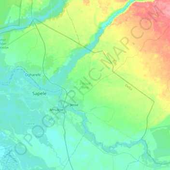
Name: Ethiope West topographic map, elevation, terrain.
Location: Ethiope West, Delta State, Nigeria (5.77175 5.56394 6.05203 5.92132)
Average elevation: 21 m
Minimum elevation: -1 m
Maximum elevation: 85 m
Thank you for supporting this site ❤️
Make a donation
Make a donation
Other topographic maps
Click on a map to view its topography, its elevation and its terrain.
Thank you for supporting this site ❤️
Make a donation
Make a donation
Thank you for supporting this site ❤️
Make a donation
Make a donation
Thank you for supporting this site ❤️
Make a donation
Make a donation