
Thank you for supporting this site ❤️
Make a donation
Make a donation
Ijebu East topographic map
Click on the map to display elevation.
Thank you for supporting this site ❤️
Make a donation
Make a donation
About this map
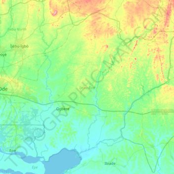
Name: Ijebu East topographic map, elevation, terrain.
Location: Ijebu East, Ogun State, Nigeria (6.54556 3.96751 7.09178 4.60959)
Average elevation: 67 m
Minimum elevation: -2 m
Maximum elevation: 337 m
Thank you for supporting this site ❤️
Make a donation
Make a donation
Other topographic maps
Click on a map to view its topography, its elevation and its terrain.
Thank you for supporting this site ❤️
Make a donation
Make a donation
Thank you for supporting this site ❤️
Make a donation
Make a donation