
Thank you for supporting this site ❤️
Make a donation
Make a donation
Yewa North topographic map
Click on the map to display elevation.
Thank you for supporting this site ❤️
Make a donation
Make a donation
About this map
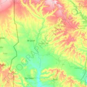
Name: Yewa North topographic map, elevation, terrain.
Location: Yewa North, Ogun State, Nigeria (6.83492 2.71254 7.41361 3.12591)
Average elevation: 87 m
Minimum elevation: 5 m
Maximum elevation: 230 m
Thank you for supporting this site ❤️
Make a donation
Make a donation
Other topographic maps
Click on a map to view its topography, its elevation and its terrain.
Thank you for supporting this site ❤️
Make a donation
Make a donation
Thank you for supporting this site ❤️
Make a donation
Make a donation