
Make a donation
Zamfara State topographic map
Click on the map to display elevation.
Make a donation
About this map
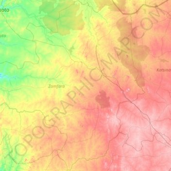
Name: Zamfara State topographic map, elevation, terrain.
Location: Zamfara State, Nigeria (10.86342 4.86075 13.18245 7.24657)
Average elevation: 449 m
Minimum elevation: 232 m
Maximum elevation: 829 m
Make a donation
Other topographic maps
Click on a map to view its topography, its elevation and its terrain.
Make a donation
Make a donation
Make a donation
Make a donation
Abuja
Nigeria > Federal Capital Territory > Municipal Area Council
The elevation is 360 metres (1,180 ft).
Average elevation: 508 m
Make a donation
Make a donation
Make a donation
Make a donation
Make a donation
Ibadan
Nigeria > Oyo State > Ibadan South West
Ibadan, coined from the phrase "Eba-Odan", which literally means 'by the edge of the meadow', came into existence in 1829, during a period of turmoil that characterized Yorubaland at the time. It was in this period that many old Yoruba cities such as old Oyo (Oyo-ile), Ijaye and Owu disappeared, and newer ones…
Average elevation: 191 m
Make a donation
Agodi gate water corporation
Nigeria > Oyo State > Ibadan North East > Ibadan
Average elevation: 228 m
Make a donation
Make a donation
Abuja
Nigeria > Federal Capital Territory > Municipal Area Council
The elevation is 360 metres (1,180 ft).
Average elevation: 508 m
Make a donation
Make a donation
Abuja
Nigeria > Federal Capital Territory > Municipal Area Council
The elevation is 360 metres (1,180 ft).
Average elevation: 508 m
Make a donation
Make a donation
Make a donation
Make a donation
Make a donation
Make a donation
Abuja
Nigeria > Federal Capital Territory > Municipal Area Council
The elevation is 360 metres (1,180 ft).
Average elevation: 508 m
Auchi
Nigeria > Edo State > Etsako West
The climate at Auchi, which has an elevation of 0 meters (None feet) above sea level, is tropical wet and dry or savanna (Aw classification). The district's average annual temperature is -0.74% lower than Nigeria's averages at 28.72 °C (83.7 °F). 183.14 millimeters (7.21 inches) of precipitation and 265.4…
Average elevation: 186 m
Make a donation
Awka
Nigeria > Anambra State > Awka South
Awka lies below 300 metres above sea in a valley on the plains of the Mamu River. Two ridges or cuestas, both lying in a north–south direction, form the major topographical features of the area. The ridges reach the highest point at Agulu just outside the Capital Territory. About six kilometers east of this,…
Average elevation: 90 m
Make a donation
Abuja
Nigeria > Federal Capital Territory > Municipal Area Council
The elevation is 360 metres (1,180 ft).
Average elevation: 508 m
Make a donation
Jos
Nigeria > Plateau State > Jos North
At an altitude of 1,217 m (3,993 ft) above sea level, Jos' climate is closer to temperate than that of the vast majority of Nigeria. Average monthly temperatures range from 21–25 °C (70–77 °F), and from mid-November to late January, night-time temperatures drop as low as 7 °C (45 °F). Hail sometimes…
Average elevation: 1,181 m
Auchi
Nigeria > Edo State > Etsako West
The climate at Auchi, which has an elevation of 0 meters (None feet) above sea level, is tropical wet and dry or savanna (Aw classification). The district's average annual temperature is -0.74% lower than Nigeria's averages at 28.72 °C (83.7 °F). 183.14 millimeters (7.21 inches) of precipitation and 265.4…
Average elevation: 186 m
Make a donation
Make a donation