
Make a donation
Turkey topographic map
Click on the map to display elevation.
Make a donation
Turkey
Turkey's topography is a diverse tapestry of mountains, plateaus, and coastal plains that create a strikingly varied landscape. The country is predominantly characterized by the Anatolian Plateau, a semi-arid highland that stretches across central Turkey, with elevations ranging from 700 to 2,000 meters. This plateau is flanked by the Pontic Mountains to the north and the Taurus Mountains to the south, both of which run parallel to the respective coastlines. In the east, the terrain becomes more rugged and elevated, culminating in Mount Ararat, Turkey's highest peak at 5,137 meters. Coastal regions, such as the Aegean and Mediterranean shores, feature narrow plains that give way to rolling hills and steep mountains, while the Black Sea coast is lined with dense forests and receives the highest precipitation in the country. This complex terrain not only shapes Turkey's diverse climates and ecosystems but also influences human activities, from agriculture in the fertile basins to tourism in the picturesque valleys and mountains.
Make a donation
About this map
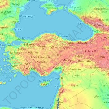
Name: Turkey topographic map, elevation, terrain.
Location: Turkey (35.80590 25.56563 42.29700 44.81766)
Average elevation: 487 m
Minimum elevation: -415 m
Maximum elevation: 5,225 m
Make a donation
Other topographic maps
Click on a map to view its topography, its elevation and its terrain.
Bangladesh
With an elevation of 1,064 m (3,491 ft), Saka Haphong (also known as Mowdok Mual) near the border with Myanmar, is claimed to be the highest peak of Bangladesh. However, it is not yet widely recognized as the highest point of the country, and most sources give the honor to Keokradong.
Average elevation: 1,488 m
Make a donation
Make a donation
Make a donation
Make a donation
Klerksdorp
South Africa > North West > Dr Kenneth Kaunda District Municipality
Average elevation: 1,346 m
Make a donation
Mbeya
Mbeya is situated at an altitude of 1,700 metres (5,500 ft), and sprawls through a narrow highland valley surrounded by a bowl of high mountains. The main language is colloquial Swahili, and the English language is extensively taught in schools.
Average elevation: 1,817 m
Make a donation
Make a donation
Abuja
Nigeria > Federal Capital Territory > Municipal Area Council
The elevation is 360 metres (1,180 ft).
Average elevation: 508 m
Make a donation
At Ta'if
Taif (Arabic: اَلطَّائِفُ, romanized: Aṭ-Ṭāʾif, lit. 'The circulated or encircled', Hejazi Arabic pronunciation: [atˤˈ tˤaː(j)ɪf]) is a city and governorate in Mecca Province in Saudi Arabia. Located at an elevation of 1,879 m (6,165 ft) in the slopes of the Hijaz Mountains, which…
Average elevation: 1,742 m
Make a donation
Dinaric Alps
Bosnia and Herzegovina > Federation of Bosnia and Herzegovina > City of Livno
Average elevation: 1,599 m
Make a donation
Junma Sichang Qilian
China > Gansu > Shandan County > Shandan horse breeding area
Average elevation: 2,558 m
Make a donation
Make a donation
Make a donation
Islamabad
Pakistan > Islamabad Capital Territory
Islamabad's micro-climate is regulated by three artificial reservoirs: Rawal, Simli, and Khanpur Dam. The latter is located on the Haro River near the town of Khanpur, about 40 kilometres (25 mi) from Islamabad. Simli Dam is 30 kilometres (19 mi) north of Islamabad. 220 acres (89 ha) of the city consists of…
Average elevation: 666 m
Kopaonik
Serbia > Rasina Administrative District > Brus Municipality
Kopaonik (Serbian Cyrillic: Копаоник; Albanian: Kopaoniku) is a mountain range located in Kosovo and Serbia. The highest point of this mountain range is the Pančić's Peak with an altitude of 2,017 m (6,617 ft). The central part of the Kopaonik plateau was declared a national park in 1981 which today…
Average elevation: 1,733 m
Make a donation
Croce di Envie - Cima Bracco
Italy > Piedmont > Cuneo > Sanfront
The Monte Bracco (though the name is sometimes shortened to Mombracco) is a mountain in the Cottian Alps with an elevation of 1,307 meters above sea level. It is located between the Valle Po, the Valle Infernotto [it], and the Cuneo plain.
Average elevation: 947 m
Make a donation
Make a donation
Make a donation
Make a donation
Make a donation
Make a donation
Make a donation
Ivel Springs Local Nature Reserve
United Kingdom > England > Hertfordshire > North Hertfordshire > Baldock
Average elevation: 72 m
Make a donation
Mapusa
Mapusa is located at 15°36′N 73°49′E / 15.60°N 73.82°E / 15.60; 73.82. It has an average elevation of 15 metres (49 feet). It lies on the banks of Mapusa River. Mapusa has a tropical climate with temperatures ranging from a high of 37 °C in summer with high levels of humidity to a low of 21 °C in winters.
Average elevation: 26 m
Little Current
Canada > Ontario > Manitoulin District > Northeastern Manitoulin and the Islands
Average elevation: 193 m
Make a donation
Buurhakaba
Somalia > Bay > Burhakaba District
Burhakaba is situated at the coordinates of 2.7991° N, 44.0794° E with an elevation of 196 meters above sea level. It lacks a permanent river, but it does have a large valley known as "Bohol Wiinti" that runs through the town from the north, east, and south-east. After seasonal rainfall, the valley supports…
Average elevation: 203 m
Make a donation
Aalborg
Denmark > North Denmark Region
The area close to the waterfront is low-lying, with an elevation averaging about 5 metres (16 ft), but there are many hills in and around city, some reaching over 60 m (200 ft). Nørresundby, on the northern side of the sound, is also a hilly area. Villages to the south of Aalborg from west to east include…
Average elevation: 17 m
Make a donation