
Make a donation
Chesapeake Bay topographic map
Click on the map to display elevation.
Make a donation
Chesapeake Bay
Tides in the Chesapeake Bay exhibit an interesting and unique behavior due to the nature of the topography (both horizontal and vertical shape), wind-driven circulation, and how the Bay interacts with oceanic tides. Research into the peculiar behavior of tides both at the northern and southern extents of the Bay began in the late 1970s. One study noted sea level fluctuations at periods of 5 days, driven by sea level changes at the Bay's mouth on the Atlantic coast and local lateral winds, and 2.5 days, caused by resonant oscillations driven by local longitudinal winds, while another study later found that the geometry of the Bay permits for a resonant period of 1.46 days.
Make a donation
About this map
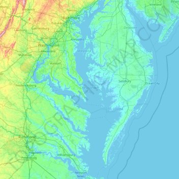
Name: Chesapeake Bay topographic map, elevation, terrain.
Location: Chesapeake Bay, Maryland, 23459, United States (36.90781 -76.53672 39.54857 -75.81095)
Average elevation: 33 m
Minimum elevation: -4 m
Maximum elevation: 539 m
Make a donation
Other topographic maps
Click on a map to view its topography, its elevation and its terrain.
Baltimore
Baltimore exhibits a diverse topography that plays a significant role in its character and development. Situated along the Patapsco River, which flows into the Chesapeake Bay, the city is positioned on the fall line that separates the Piedmont Plateau to the west from the Atlantic Coastal Plain to the east.…
Average elevation: 65 m
Make a donation
Dundalk
United States > Maryland > Baltimore County
Most of Dundalk is flat and very near sea level, with a few small hills close to the city of Baltimore to the west. Dundalk is part of the Atlantic Coastal Plain. Elevations range from sea level on the shore of the Chesapeake Bay to approximately 40 feet (12 m) above sea level along the northern reaches of…
Average elevation: 33 m
Andrews Manor
United States > Maryland > Prince George's County > Camp Springs
Average elevation: 79 m
Make a donation
Make a donation
Make a donation
Zihlman
United States > Maryland > Allegany County
Zihlman is located along Maryland Route 36, 1.5 miles (2.4 km) northeast of and 500 feet (150 m) lower in elevation than Frostburg. Mount Savage is 3 miles (5 km) further northeast along MD 36.
Average elevation: 590 m
Make a donation
Make a donation
Make a donation
Make a donation
Make a donation
Lavale Community Park
United States > Maryland > Allegany County > Allegany Grove
Average elevation: 354 m
Make a donation
Make a donation
Make a donation
Make a donation
Make a donation
Make a donation
Make a donation
Make a donation
Make a donation
Make a donation
Make a donation
Make a donation
Make a donation
Make a donation
Make a donation
Make a donation