
Make a donation
Portugal topographic map
Click on the map to display elevation.
Make a donation
Portugal
Portugal's topography is a diverse tapestry of rugged mountains, rolling plains, and extensive coastlines. In the north, the landscape is predominantly mountainous, with the Serra da Estrela range featuring Torre, the highest peak on mainland Portugal at 1,993 meters. This region is characterized by steep slopes and deep valleys carved by rivers such as the Douro and Mondego. Moving southward, the terrain transitions into the undulating plains of the Alentejo, marked by gentle hills and expansive agricultural fields. The southernmost region, the Algarve, boasts a varied landscape of limestone caves, grottoes, and sandy beaches along its coastline. Portugal's extensive Atlantic coastline stretches over 1,700 kilometers, featuring a mix of rugged cliffs and sandy shores. Additionally, the archipelagos of Madeira and the Azores, both autonomous regions of Portugal, are known for their volcanic origins, resulting in dramatic landscapes of craters, lakes, and lush vegetation.
Make a donation
About this map
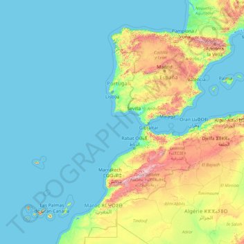
Name: Portugal topographic map, elevation, terrain.
Location: Portugal (29.82825 -31.55753 42.15431 -6.18916)
Average elevation: 268 m
Minimum elevation: -2 m
Maximum elevation: 3,622 m
Make a donation
Other topographic maps
Click on a map to view its topography, its elevation and its terrain.
Bangladesh
With an elevation of 1,064 m (3,491 ft), Saka Haphong (also known as Mowdok Mual) near the border with Myanmar, is claimed to be the highest peak of Bangladesh. However, it is not yet widely recognized as the highest point of the country, and most sources give the honor to Keokradong.
Average elevation: 1,488 m
Make a donation
Make a donation
Make a donation
Make a donation
Make a donation
Make a donation
Croce di Envie - Cima Bracco
Italy > Piedmont > Cuneo > Sanfront
The Monte Bracco (though the name is sometimes shortened to Mombracco) is a mountain in the Cottian Alps with an elevation of 1,307 meters above sea level. It is located between the Valle Po, the Valle Infernotto [it], and the Cuneo plain.
Average elevation: 947 m
Klerksdorp
South Africa > North West > Dr Kenneth Kaunda District Municipality
Average elevation: 1,346 m
Make a donation
Make a donation
Make a donation
Make a donation
Abuja
Nigeria > Federal Capital Territory > Municipal Area Council
The elevation is 360 metres (1,180 ft).
Average elevation: 508 m
Make a donation
At Ta'if
Taif (Arabic: اَلطَّائِفُ, romanized: Aṭ-Ṭāʾif, lit. 'The circulated or encircled', Hejazi Arabic pronunciation: [atˤˈ tˤaː(j)ɪf]) is a city and governorate in Mecca Province in Saudi Arabia. Located at an elevation of 1,879 m (6,165 ft) in the slopes of the Hijaz Mountains, which…
Average elevation: 1,742 m
Make a donation
Dinaric Alps
Bosnia and Herzegovina > Federation of Bosnia and Herzegovina > City of Livno
Average elevation: 1,599 m
Make a donation
Junma Sichang Qilian
China > Gansu > Shandan County > Shandan horse breeding area
Average elevation: 2,558 m
Make a donation
Make a donation
Make a donation
Islamabad
Pakistan > Islamabad Capital Territory
Islamabad's micro-climate is regulated by three artificial reservoirs: Rawal, Simli, and Khanpur Dam. The latter is located on the Haro River near the town of Khanpur, about 40 kilometres (25 mi) from Islamabad. Simli Dam is 30 kilometres (19 mi) north of Islamabad. 220 acres (89 ha) of the city consists of…
Average elevation: 666 m
Make a donation
Kopaonik
Serbia > Rasina Administrative District > Brus Municipality
Kopaonik (Serbian Cyrillic: Копаоник; Albanian: Kopaoniku) is a mountain range located in Kosovo and Serbia. The highest point of this mountain range is the Pančić's Peak with an altitude of 2,017 m (6,617 ft). The central part of the Kopaonik plateau was declared a national park in 1981 which today…
Average elevation: 1,733 m
Make a donation
Make a donation
Make a donation
Make a donation
Make a donation
Mbeya
Mbeya is situated at an altitude of 1,700 metres (5,500 ft), and sprawls through a narrow highland valley surrounded by a bowl of high mountains. The main language is colloquial Swahili, and the English language is extensively taught in schools.
Average elevation: 1,817 m
Make a donation
Make a donation
Make a donation