
Make a donation
Tunisia topographic map
Click on the map to display elevation.
Make a donation
Tunisia
Though it is relatively small in size, Tunisia has great environmental diversity due to its north–south extent. Its east–west extent is limited. Differences in Tunisia, like the rest of the Maghreb, are largely north–south environmental differences defined by sharply decreasing rainfall southward from any point. The Dorsal, the eastern extension of the Atlas Mountains, runs across Tunisia in a northeasterly direction from the Algerian border in the west to the Cape Bon peninsula in the east. North of the Dorsal is the Tell, a region characterized by low, rolling hills and plains, again an extension of mountains to the west in Algeria. In the Khroumerie, the northwestern corner of the Tunisian Tell, elevations reach 1,050 metres (3,440 ft) and snow occurs in winter.
Make a donation
About this map
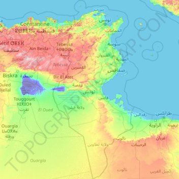
Name: Tunisia topographic map, elevation, terrain.
Location: Tunisia (30.22906 7.52198 37.76121 11.88011)
Average elevation: 240 m
Minimum elevation: -32 m
Maximum elevation: 2,237 m
Make a donation
Other topographic maps
Click on a map to view its topography, its elevation and its terrain.
Make a donation
Make a donation
Make a donation
Make a donation
Make a donation
Make a donation
Make a donation
Make a donation
Make a donation
Make a donation
Make a donation
Make a donation
Make a donation
Make a donation
Make a donation
Make a donation
Bangladesh
With an elevation of 1,064 m (3,491 ft), Saka Haphong (also known as Mowdok Mual) near the border with Myanmar, is claimed to be the highest peak of Bangladesh. However, it is not yet widely recognized as the highest point of the country, and most sources give the honor to Keokradong.
Average elevation: 1,488 m
Make a donation
Make a donation
Agodi gate water corporation
Nigeria > Oyo State > Ibadan North East > Ibadan
Average elevation: 228 m
Make a donation
Ibadan
Nigeria > Oyo State > Ibadan South West
Ibadan, coined from the phrase "Eba-Odan", which literally means 'by the edge of the meadow', came into existence in 1829, during a period of turmoil that characterized Yorubaland at the time. It was in this period that many old Yoruba cities such as old Oyo (Oyo-ile), Ijaye and Owu disappeared, and newer ones…
Average elevation: 191 m
Make a donation
Abuja
Nigeria > Federal Capital Territory > Municipal Area Council
The elevation is 360 metres (1,180 ft).
Average elevation: 508 m
Make a donation
Make a donation
At Ta'if
Taif (Arabic: اَلطَّائِفُ, romanized: Aṭ-Ṭāʾif, lit. 'The circulated or encircled', Hejazi Arabic pronunciation: [atˤˈ tˤaː(j)ɪf]) is a city and governorate in Mecca Province in Saudi Arabia. Located at an elevation of 1,879 m (6,165 ft) in the slopes of the Hijaz Mountains, which…
Average elevation: 1,742 m
Make a donation
Dinaric Alps
Bosnia and Herzegovina > Federation of Bosnia and Herzegovina > City of Livno
Average elevation: 1,599 m
Make a donation
Junma Sichang Qilian
China > Gansu > Shandan County > Shandan horse breeding area
Average elevation: 2,558 m
Make a donation