
Kano State topographic map
Click on the map to display elevation.
About this map
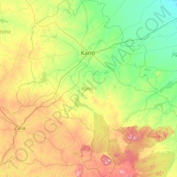
Name: Kano State topographic map, elevation, terrain.
Location: Kano State, Nigeria (10.54336 7.67517 12.60460 9.36031)
Average elevation: 546 m
Minimum elevation: 364 m
Maximum elevation: 1,178 m
Other topographic maps
Click on a map to view its topography, its elevation and its terrain.
Abuja
Nigeria > Federal Capital Territory > Municipal Area Council
The elevation is 360 metres (1,180 ft).
Average elevation: 508 m
Auchi
Nigeria > Edo State > Etsako West
The climate at Auchi, which has an elevation of 0 meters (None feet) above sea level, is tropical wet and dry or savanna (Aw classification). The district's average annual temperature is -0.74% lower than Nigeria's averages at 28.72 °C (83.7 °F). 183.14 millimeters (7.21 inches) of precipitation and 265.4…
Average elevation: 186 m
Ibadan
Nigeria > Oyo State > Ibadan South West
Ibadan, coined from the phrase "Eba-Odan", which literally means 'by the edge of the meadow', came into existence in 1829, during a period of turmoil that characterized Yorubaland at the time. It was in this period that many old Yoruba cities such as old Oyo (Oyo-ile), Ijaye and Owu disappeared, and newer ones…
Average elevation: 191 m
Agodi gate water corporation
Nigeria > Oyo State > Ibadan North East > Ibadan
Average elevation: 228 m
Jos
Nigeria > Plateau State > Jos North
At an altitude of 1,217 m (3,993 ft) above sea level, Jos' climate is closer to temperate than that of the vast majority of Nigeria. Average monthly temperatures range from 21–25 °C (70–77 °F), and from mid-November to late January, night-time temperatures drop as low as 7 °C (45 °F). Hail sometimes…
Average elevation: 1,181 m
Galadimawa Village
Nigeria > Federal Capital Territory > Municipal Area Council
Average elevation: 446 m
Jos Plateau
Nigeria > Plateau State > Jos East
It covers 8600 km2 and is bounded by 300–600 m escarpments around much of its boundary. With an average altitude of 1,280 m, it is the largest area over 1,000m in Nigeria, with a high point of 1,776m, in the Shere Hills. Several rivers have their sources on the plateau. The Kaduna River drains the western…
Average elevation: 951 m
Lanre Shittu Motors, Asa-Dam Road, Ilorin, Nigeria
Nigeria > Kwara State > Ilorin West > Oja Oba, Oko Erin, Nigeria
Average elevation: 322 m
Abuja
Nigeria > Federal Capital Territory > Municipal Area Council
The elevation is 360 metres (1,180 ft).
Average elevation: 508 m
Jos
Nigeria > Plateau State > Jos North
At an altitude of 1,217 m (3,993 ft) above sea level, Jos' climate is closer to temperate than that of the vast majority of Nigeria. Average monthly temperatures range from 21–25 °C (70–77 °F), and from mid-November to late January, night-time temperatures drop as low as 7 °C (45 °F). Hail sometimes…
Average elevation: 1,181 m