
Make a donation
Boké Region topographic map
Click on the map to display elevation.
Make a donation
About this map
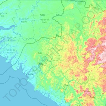
Name: Boké Region topographic map, elevation, terrain.
Location: Boké Region, Guinea (9.80887 -15.36672 12.67563 -12.56850)
Average elevation: 156 m
Minimum elevation: -2 m
Maximum elevation: 1,241 m
Make a donation
Other topographic maps
Click on a map to view its topography, its elevation and its terrain.
Make a donation
Mount Nimba Strict Nature Reserve
Guinea > Nzérékoré Region > Lola Prefecture
The Nimba Range has a sub-equatorial montane climate. Temperature changes extremely with altitude, with a daytime maximum ranging between 24 °C and 33 °C, and the nightly minimum can fall below 10 °C. Some parts of the reserve receive significantly less precipitation, due to rain-shadow effect of the high…
Average elevation: 657 m
Fouta Djallon
Guinea > Mamou Region > Pita Prefecture
Fouta-Djallon consists mainly of rolling grasslands, at an average elevation of about 900 m (3,000 ft). The highest point, Mount Loura, rises to 1,515 m (4,970 ft). The plateau consists of thick sandstone formations that overlie granitic basement rock. Erosion by rain and rivers has carved deep jungle canyons…
Average elevation: 1,143 m
Make a donation
Fouta Djallon
Guinea > Mamou Region > Pita Prefecture
Fouta-Djallon consists mainly of rolling grasslands, at an average elevation of about 914 m (3,000 ft), and is the second highest land in West Africa behind Mount Cameroon. The highest point, Mount Loura, rises to 1,515 m (4,970 ft). The plateau consists of thick sandstone formations that overlie granitic…
Average elevation: 1,143 m
Make a donation
Make a donation
Make a donation
Make a donation
Make a donation
Make a donation
Pita
Guinea > Mamou Region > Pita Prefecture
Th geographical coordinates of the town are 11°03'16.0"N, 12°23'46.0"W (Latitude:11.054444; Longitude:-12.396111). The town is located at an average elevation of 972.6 metres (3,191 ft) above mean sea level.
Average elevation: 937 m
Labé
Guinea > Labé Region > Labé Prefecture
Labé has a tropical savanna climate (Köppen climate classification Aw) with extreme temperature differences between day and night due to the city’s altitude of over 1,000 metres or 3,280 feet. It is as hot by day as the coast of Guinea all year round, but cold to comfortable at night due to lower heat…
Average elevation: 988 m
Make a donation
Make a donation
Make a donation
Make a donation
Make a donation