
Make a donation
Bulgaria topographic map
Click on the map to display elevation.
Make a donation
Bulgaria
Bulgaria is a middle-sized country situated in Southeast Europe, in the east of the Balkans. Its territory covers an area of 110,994 square kilometres (42,855 sq mi), while land borders with its five neighbouring countries run a total length of 1,808 kilometres (1,123 mi), and its coastline is 354 kilometres (220 mi) long. Bulgaria's geographic coordinates are 43° N 25° E. The most notable topographical features of the country are the Danubian Plain, the Balkan Mountains, the Upper Thracian Plain, and the Rila-Rhodope massif. The southern edge of the Danubian Plain slopes upward into the foothills of the Balkans, while the Danube defines the border with Romania. The Thracian Plain is roughly triangular, beginning southeast of Sofia and broadening as it reaches the Black Sea coast.
Make a donation
About this map
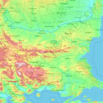
Name: Bulgaria topographic map, elevation, terrain.
Location: Bulgaria (41.23537 22.35715 44.21622 28.88754)
Average elevation: 300 m
Minimum elevation: -3 m
Maximum elevation: 2,750 m
Make a donation
Other topographic maps
Click on a map to view its topography, its elevation and its terrain.
Make a donation
Make a donation
Make a donation
Make a donation
Make a donation
Make a donation
Make a donation
Make a donation
Make a donation
Make a donation
Make a donation
Make a donation
Make a donation
Make a donation
Make a donation
Make a donation
Bangladesh
With an elevation of 1,064 m (3,491 ft), Saka Haphong (also known as Mowdok Mual) near the border with Myanmar, is claimed to be the highest peak of Bangladesh. However, it is not yet widely recognized as the highest point of the country, and most sources give the honor to Keokradong.
Average elevation: 1,488 m
Make a donation
Agodi gate water corporation
Nigeria > Oyo State > Ibadan North East > Ibadan
Average elevation: 228 m
Make a donation
Ibadan
Nigeria > Oyo State > Ibadan South West
Ibadan, coined from the phrase "Eba-Odan", which literally means 'by the edge of the meadow', came into existence in 1829, during a period of turmoil that characterized Yorubaland at the time. It was in this period that many old Yoruba cities such as old Oyo (Oyo-ile), Ijaye and Owu disappeared, and newer ones…
Average elevation: 191 m
Make a donation
Make a donation
Abuja
Nigeria > Federal Capital Territory > Municipal Area Council
The elevation is 360 metres (1,180 ft).
Average elevation: 508 m
Make a donation
At Ta'if
Taif (Arabic: اَلطَّائِفُ, romanized: Aṭ-Ṭāʾif, lit. 'The circulated or encircled', Hejazi Arabic pronunciation: [atˤˈ tˤaː(j)ɪf]) is a city and governorate in Mecca Province in Saudi Arabia. Located at an elevation of 1,879 m (6,165 ft) in the slopes of the Hijaz Mountains, which…
Average elevation: 1,742 m
Make a donation
Make a donation
Dinaric Alps
Bosnia and Herzegovina > Federation of Bosnia and Herzegovina > City of Livno
Average elevation: 1,599 m
Junma Sichang Qilian
China > Gansu > Shandan County > Shandan horse breeding area
Average elevation: 2,558 m
Make a donation
Make a donation