
Cross River State topographic map
Click on the map to display elevation.
Cross River State
Like few other Nigerian states, the climate of Cross River state is tropical. Not only this, the state is also characterized by relative humidity. The average temperature of the state is between 15°C and 30°C. However, this climatic condition is different in locations within the Cross River state such as the high plateau of Obudu, which has a record of a fall in temperature between 4°C and 10°C, as a result of the high altitude of this area. The capital city of the State, Calabar, has a significant record of rainfall within the year, while the dry season has less significant effect in the state due to the depth of rainfall experienced. Based on the records presented by the Climate Data of the state, the annual rainfall of Cross River state is 3306mm (130.2 inches).
About this map
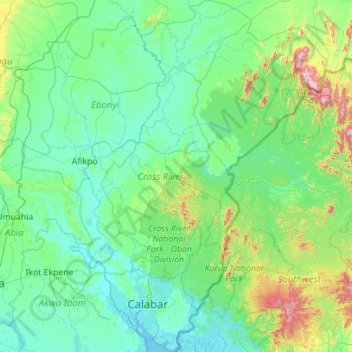
Name: Cross River State topographic map, elevation, terrain.
Location: Cross River State, Nigeria (4.67444 7.84087 6.89641 9.47441)
Average elevation: 173 m
Minimum elevation: -1 m
Maximum elevation: 1,849 m
Other topographic maps
Click on a map to view its topography, its elevation and its terrain.
Ibadan
Nigeria > Oyo State > Ibadan South West
Ibadan, coined from the phrase "Eba-Odan", which literally means 'by the edge of the meadow', came into existence in 1829, during a period of turmoil that characterized Yorubaland at the time. It was in this period that many old Yoruba cities such as old Oyo (Oyo-ile), Ijaye and Owu disappeared, and newer ones…
Average elevation: 191 m
Abuja
Nigeria > Federal Capital Territory > Municipal Area Council
The elevation is 360 metres (1,180 ft).
Average elevation: 508 m
Auchi
Nigeria > Edo State > Etsako West
The climate at Auchi, which has an elevation of 0 meters (None feet) above sea level, is tropical wet and dry or savanna (Aw classification). The district's average annual temperature is -0.74% lower than Nigeria's averages at 28.72 °C (83.7 °F). 183.14 millimeters (7.21 inches) of precipitation and 265.4…
Average elevation: 186 m
Agodi gate water corporation
Nigeria > Oyo State > Ibadan North East > Ibadan
Average elevation: 228 m
Jos
Nigeria > Plateau State > Jos North
At an altitude of 1,217 m (3,993 ft) above sea level, Jos' climate is closer to temperate than that of the vast majority of Nigeria. Average monthly temperatures range from 21–25 °C (70–77 °F), and from mid-November to late January, night-time temperatures drop as low as 7 °C (45 °F). Hail sometimes…
Average elevation: 1,181 m
Galadimawa Village
Nigeria > Federal Capital Territory > Municipal Area Council
Average elevation: 446 m
Jos Plateau
Nigeria > Plateau State > Jos East
It covers 8600 km2 and is bounded by 300–600 m escarpments around much of its boundary. With an average altitude of 1,280 m, it is the largest area over 1,000m in Nigeria, with a high point of 1,776m, in the Shere Hills. Several rivers have their sources on the plateau. The Kaduna River drains the western…
Average elevation: 951 m
Lanre Shittu Motors, Asa-Dam Road, Ilorin, Nigeria
Nigeria > Kwara State > Ilorin West > Oja Oba, Oko Erin, Nigeria
Average elevation: 322 m
Abuja
Nigeria > Federal Capital Territory > Municipal Area Council
The elevation is 360 metres (1,180 ft).
Average elevation: 508 m