
Make a donation
South America topographic map
Click on the map to display elevation.
Make a donation
South America
The east-central Brazilian plateau has a humid and warm tropical climate. The northern and eastern parts of the Argentine pampas have a humid subtropical climate with dry winters and humid summers of the Chinese type, while the western and eastern ranges have a subtropical climate of the dinaric type. At the highest points of the Andean region, climates are colder than the ones occurring at the highest point of the Norwegian fjords. In the Andean plateaus, the warm climate prevails, although it is tempered by the altitude, while in the coastal strip, there is an equatorial climate of the Guinean type. From this point until the north of the Chilean coast appear, successively, Mediterranean oceanic climate, temperate of the Breton type and, already in Tierra del Fuego, cold climate of the Siberian type.
Make a donation
About this map
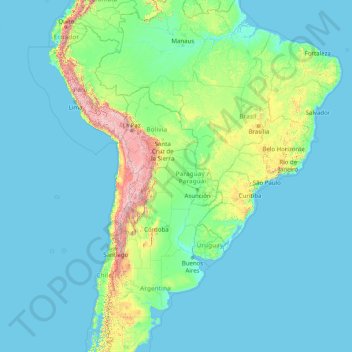
Name: South America topographic map, elevation, terrain.
Location: South America (-46.00022 -86.00066 3.99978 -36.00066)
Average elevation: 283 m
Minimum elevation: -1 m
Maximum elevation: 6,497 m
Make a donation
Other topographic maps
Click on a map to view its topography, its elevation and its terrain.
Nigeria
Nigeria's most expansive topographical region is that of the valleys of the Niger and Benue river valleys (which merge and form a Y-shape). To the southwest of the Niger is a "rugged" highland. To the southeast of the Benue are hills and mountains, which form the Mambilla Plateau, the highest plateau in…
Average elevation: 347 m
Make a donation
Monaco
The four traditional quartiers of Monaco are Monaco-Ville, La Condamine, Monte Carlo and Fontvieille. However, the suburb of Moneghetti, the high-level part of La Condamine, is generally seen today as an effective fifth Quartier of Monaco, having a very distinct atmosphere and topography when compared with…
Average elevation: 105 m
Make a donation
Make a donation
Make a donation
Make a donation
Mobile
United States > Alabama > Mobile County
According to the United States Census Bureau, the city has a total area of 180.1 square miles (466 km2), with 139.5 square miles (361 km2) of it being land, and 40.6 square miles (105.2 km2), or 22.5% of the total, being covered by water. The elevation in Mobile ranges from 10 feet (3 m) on Water Street in…
Average elevation: 16 m
Make a donation
Make a donation
Make a donation
Central Business District
Nigeria > Federal Capital Territory > Municipal Area Council
Average elevation: 494 m
Make a donation
Make a donation
Woodhall Spa
United Kingdom > England > Lincolnshire > East Lindsey > Woodhall Spa
Average elevation: 9 m
Tbilisi
Most of the raions are named after historic quarters of the city. The citizens of Tbilisi widely recognize an informal system of smaller historic neighborhoods. Such neighborhoods are several, however, constituting a kind of hierarchy, because most of them have lost their distinctive topographic limits. The…
Average elevation: 756 m
Make a donation
Philippines
Its highest mountain is Mount Apo on Mindanao, with an altitude of 2,954 meters (9,692 ft) above sea level. The Philippines' longest river is the Cagayan River in northern Luzon, which flows for about 520 kilometers (320 mi). Manila Bay, on which is the capital city of Manila, is connected to Laguna de Bay…
Average elevation: 33 m
Bosnia and Herzegovina
Overall, nearly 50% of Bosnia and Herzegovina is forested. Most forest areas are in the centre, east and west parts of Bosnia. Herzegovina has a drier Mediterranean climate, with dominant karst topography. Northern Bosnia (Posavina) contains very fertile agricultural land along the Sava river and the…
Average elevation: 534 m
Slovenia
The term "Karst topography" refers to that of southwestern Slovenia's Karst Plateau, a limestone region of underground rivers, gorges, and caves, between Ljubljana and the Mediterranean Sea. On the Pannonian plain to the East and Northeast, toward the Croatian and Hungarian borders, the landscape is…
Average elevation: 567 m
Make a donation
Croatia
The territory covers 56,594 square kilometres (21,851 square miles), consisting of 56,414 square kilometres (21,782 square miles) of land and 128 square kilometres (49 square miles) of water. It is the world's 127th largest country. Elevation ranges from the mountains of the Dinaric Alps with the highest point…
Average elevation: 323 m
Hungary
Average elevation: 259 m
Make a donation
Make a donation
Make a donation
Make a donation
Make a donation
Make a donation
Make a donation
United Kingdom
Most of the United Kingdom has a temperate climate, with generally cool temperatures and plentiful rainfall all year round. The temperature varies with the seasons seldom dropping below 0 °C (32 °F) or rising above 30 °C (86 °F). Some parts, away from the coast, of upland England, Wales, Northern Ireland…
Average elevation: 42 m
Cross River State
Like few other Nigerian states, the climate of Cross River state is tropical. Not only this, the state is also characterized by relative humidity. The average temperature of the state is between 15°C and 30°C. However, this climatic condition is different in locations within the Cross River state such as the…
Average elevation: 173 m
Make a donation
Make a donation
Make a donation
Make a donation
Jumla
Geographically, Jumla is a Himalayan mountainous region of which elevations ranges from 915 metres (3,002 ft) to 4,679 metres (15,351 ft). The Higher Himalayan Region consists of Patarasi and Kanjirowa Himalayan ranges. The major rivers in Jumla are Hima, Tila and Jawa.
Average elevation: 3,373 m
Caracas
Venezuela > Capital District > Municipio Libertador
Caracas is contained entirely within a valley of the Venezuelan Central Range, and is separated from the Caribbean coast by a roughly 15-kilometer (9 mi) expanse of El Ávila National Park. The valley is relatively small and quite irregular. The altitude varies between 870 and 1,043 meters (2,854 and 3,422 ft)…
Average elevation: 759 m
Make a donation
Make a donation