
Nigeria topographic map
Click on the map to display elevation.
Nigeria
Nigeria's most expansive topographical region is that of the valleys of the Niger and Benue river valleys (which merge and form a Y-shape). To the southwest of the Niger is a "rugged" highland. To the southeast of the Benue are hills and mountains, which form the Mambilla Plateau, the highest plateau in Nigeria. This plateau extends through the border with Cameroon, where the montane land is part of the Bamenda Highlands of Cameroon.
About this map
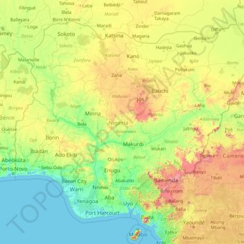
Name: Nigeria topographic map, elevation, terrain.
Location: Nigeria (4.06910 2.67693 13.88565 14.67801)
Average elevation: 347 m
Minimum elevation: -3 m
Maximum elevation: 3,507 m
Other topographic maps
Click on a map to view its topography, its elevation and its terrain.
Abuja
Nigeria > Federal Capital Territory > Municipal Area Council
The elevation is 360 metres (1,180 ft).
Average elevation: 508 m
Jos Plateau
Nigeria > Plateau State > Jos East
It covers 8600 km2 and is bounded by 300–600 m escarpments around much of its boundary. With an average altitude of 1,280 m, it is the largest area over 1,000m in Nigeria, with a high point of 1,776m, in the Shere Hills. Several rivers have their sources on the plateau. The Kaduna River drains the western…
Average elevation: 951 m
Galadimawa Village
Nigeria > Federal Capital Territory > Municipal Area Council
Average elevation: 446 m
Jos
Nigeria > Plateau State > Jos North
At an altitude of 1,217 m (3,993 ft) above sea level, Jos' climate is closer to temperate than that of the vast majority of Nigeria. Average monthly temperatures range from 21–25 °C (70–77 °F), and from mid-November to late January, night-time temperatures drop as low as 7 °C (45 °F). Hail sometimes…
Average elevation: 1,181 m