
Make a donation
Philippines topographic map
Click on the map to display elevation.
Make a donation
Philippines
Its highest mountain is Mount Apo on Mindanao, with an altitude of 2,954 meters (9,692 ft) above sea level. The Philippines' longest river is the Cagayan River in northern Luzon, which flows for about 520 kilometers (320 mi). Manila Bay, on which is the capital city of Manila, is connected to Laguna de Bay (the country's largest lake) by the Pasig River.
Make a donation
About this map
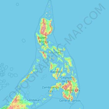
Name: Philippines topographic map, elevation, terrain.
Location: Philippines (4.38333 114.10037 21.32193 126.80308)
Average elevation: 33 m
Minimum elevation: -1 m
Maximum elevation: 2,639 m
Make a donation
Other topographic maps
Click on a map to view its topography, its elevation and its terrain.
Abuja
Nigeria > Federal Capital Territory > Municipal Area Council
The elevation is 360 metres (1,180 ft).
Average elevation: 508 m
Make a donation
Make a donation
Make a donation
Jos Plateau
Nigeria > Plateau State > Jos East
It covers 8600 km2 and is bounded by 300–600 m escarpments around much of its boundary. With an average altitude of 1,280 m, it is the largest area over 1,000m in Nigeria, with a high point of 1,776m, in the Shere Hills. Several rivers have their sources on the plateau. The Kaduna River drains the western…
Average elevation: 951 m
Galadimawa Village
Nigeria > Federal Capital Territory > Municipal Area Council
Average elevation: 446 m
Make a donation
Make a donation
Make a donation
Make a donation
Make a donation
Make a donation
Make a donation
Make a donation
Make a donation
Make a donation
Make a donation
Make a donation
Make a donation
Make a donation
Make a donation
Jos
Nigeria > Plateau State > Jos North
At an altitude of 1,217 m (3,993 ft) above sea level, Jos' climate is closer to temperate than that of the vast majority of Nigeria. Average monthly temperatures range from 21–25 °C (70–77 °F), and from mid-November to late January, night-time temperatures drop as low as 7 °C (45 °F). Hail sometimes…
Average elevation: 1,181 m
Make a donation
Make a donation
Make a donation
Make a donation
Make a donation
Make a donation
Make a donation