
Switzerland topographic map
Interactive map
Click on the map to display elevation.
Switzerland
Switzerland lies between latitudes 45° and 48° N, and longitudes 5° and 11° E. It contains three basic topographical areas: the Swiss Alps to the south, the Swiss Plateau or Central Plateau, and the Jura mountains on the west. The Alps are a high mountain range running across the central-south of the country, constituting about 60% of the country's total area. The majority of the Swiss population live in the Swiss Plateau. Among the high valleys of the Swiss Alps many glaciers are found, totalling an area of 1,063 square kilometres (410 sq mi). From these originate the headwaters of several major rivers, such as the Rhine, Inn, Ticino and Rhône, which flow in the four cardinal directions into the whole of Europe. The hydrographic network includes several of the largest bodies of freshwater in Central and Western Europe, among which are included Lake Geneva (also called le Lac Léman in French), Lake Constance (known as Bodensee in German) and Lake Maggiore. Switzerland has more than 1500 lakes, and contains 6% of Europe's stock of fresh water. Lakes and glaciers cover about 6% of the national territory. The largest lake is Lake Geneva, in western Switzerland shared with France. The Rhône is both the main source and outflow of Lake Geneva. Lake Constance is the second largest Swiss lake and, like the Lake Geneva, an intermediate step by the Rhine at the border to Austria and Germany. While the Rhône flows into the Mediterranean Sea at the French Camargue region and the Rhine flows into the North Sea at Rotterdam in the Netherlands, about 1,000 kilometres (620 miles) apart, both springs are only about 22 kilometres (14 miles) apart from each other in the Swiss Alps.
About this map
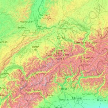
Name: Switzerland topographic map, elevation, terrain.
Location: Switzerland (45.81796 5.95583 47.80845 10.49229)
Average elevation: 1,016 m
Minimum elevation: 41 m
Maximum elevation: 4,564 m
Other topographic maps
Click on a map to view its topography, its elevation and its terrain.
Klerksdorp
South Africa > North West > Dr Kenneth Kaunda District Municipality
Average elevation: 1,346 m
Stilfontein
South Africa > North West > Dr Kenneth Kaunda District Municipality > Matlosana Local Municipality
Average elevation: 1,346 m
Quilchena
Canada > British Columbia > Thompson-Nicola Regional District > Area M (Beautiful Nicola Valley - North)
Average elevation: 677 m
Anfa Park منتزه أنفا
Morocco > Pachalik de Casablanca باشوية الدار البيضاء > Casablanca
Average elevation: 50 m
Memari
India > West Bengal > Memari - I
Memari is located at 23°12′N 88°07′E / 23.2°N 88.12°E / 23.2; 88.12. It has an average elevation of 25 metres (82 feet).
Average elevation: 21 m
Matador Wildlife Management Area
United States > Texas > Cottle County > Paducah
Average elevation: 573 m
Europe
In general, Europe is not just colder towards the north compared to the south, but it also gets colder from the west towards the east. The climate is more oceanic in the west and less so in the east. This can be illustrated by the following table of average temperatures at locations roughly following the 64th,…
Average elevation: 223 m
Marcuello
Spain > Aragon > Hoya de Huesca / Plana de Uesca > Loarre > Linás de Marcuello
Average elevation: 863 m
Ankara
Ankara has a cold semi-arid climate under the Köppen climate classification (BSk), while under the Trewartha climate classification, the city is classified as humid continental (Dc). Due to its elevation and inland location, Ankara has cold and snowy winters, and hot and dry summers. Rainfall occurs mostly…
Average elevation: 1,082 m
Antalya
While the city itself only has modest elevation changes, Antalya has high mountains in all directions to its interior. With moisture being trapped, the local climate thus has high winter rainfall, while the interior bay setting results in very hot summers for a coastal city.
Average elevation: 117 m
Khandwa
India > Madhya Pradesh > Khandwa Nagar Tahsil
Khandwa is located at 21°50′N 76°20′E / 21.83°N 76.33°E / 21.83; 76.33. It has an average elevation of 313 metres (1026 feet).
Average elevation: 325 m
Ujjain
India > Madhya Pradesh > Ujjain NagarTahsil
Ujjain is located in the west-central part of India, and is north of the upper limit of the Vindhya mountain ranges. Located on the Malwa plateau, it is higher than the north Indian plains and the land rises towards the Vindhya Range to the south. Ujjain's coordinates are 23°10′N 75°46′E /…
Average elevation: 501 m
Skinnies Lake
United States > Michigan > Marquette County > Humboldt Township
Average elevation: 453 m
Ђаловића клисура
Serbia > Central Serbia > Zlatibor Administrative District > Sjenica Municipality > Crvsko
Average elevation: 1,091 m
Fouta Djallon
Guinea > Mamou Region > Pita Prefecture
Fouta-Djallon consists mainly of rolling grasslands, at an average elevation of about 900 m (3,000 ft). The highest point, Mount Loura, rises to 1,515 m (4,970 ft). The plateau consists of thick sandstone formations that overlie granitic basement rock. Erosion by rain and rivers has carved deep jungle canyons…
Average elevation: 1,143 m
Africa
Average elevation: 462 m
Erickson
Canada > British Columbia > Regional District of Central Kootenay > Area B (Goat River Valley)
Average elevation: 680 m
Mount Rainier
United States > Washington > Pierce County
Mount Rainier (/reɪˈnɪər/ ray-NEER), also known as Tahoma, is a large active stratovolcano in the Cascade Range of the Pacific Northwest in the United States. The mountain is located in Mount Rainier National Park about 59 miles (95 km) south-southeast of Seattle. With an officially recognized summit…
Average elevation: 3,911 m
Erg Chech
It is an almost uninhabited part of the greater Sahara Desert, an inhospitable desert region with long, extremely hot summers and short, very warm winters. The Erg Chech is a vast sandy expanse including compound and complex linear and star dunes. The mean elevation of the Erg Chech is just above 300 m,…
Average elevation: 335 m