
Switzerland topographic map
Interactive map
Click on the map to display elevation.
Switzerland
Switzerland lies between latitudes 45° and 48° N, and longitudes 5° and 11° E. It contains three basic topographical areas: the Swiss Alps to the south, the Swiss Plateau or Central Plateau, and the Jura mountains on the west. The Alps are a high mountain range running across the central-south of the country, constituting about 60% of the country's total area. The majority of the Swiss population live in the Swiss Plateau. Among the high valleys of the Swiss Alps many glaciers are found, totalling an area of 1,063 square kilometres (410 sq mi). From these originate the headwaters of several major rivers, such as the Rhine, Inn, Ticino and Rhône, which flow in the four cardinal directions into the whole of Europe. The hydrographic network includes several of the largest bodies of freshwater in Central and Western Europe, among which are included Lake Geneva (also called le Lac Léman in French), Lake Constance (known as Bodensee in German) and Lake Maggiore. Switzerland has more than 1500 lakes, and contains 6% of Europe's stock of fresh water. Lakes and glaciers cover about 6% of the national territory. The largest lake is Lake Geneva, in western Switzerland shared with France. The Rhône is both the main source and outflow of Lake Geneva. Lake Constance is the second largest Swiss lake and, like the Lake Geneva, an intermediate step by the Rhine at the border to Austria and Germany. While the Rhône flows into the Mediterranean Sea at the French Camargue region and the Rhine flows into the North Sea at Rotterdam in the Netherlands, about 1,000 kilometres (620 miles) apart, both springs are only about 22 kilometres (14 miles) apart from each other in the Swiss Alps.
About this map
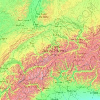
Name: Switzerland topographic map, elevation, terrain.
Location: Switzerland (45.81797 5.95591 47.80846 10.49229)
Average elevation: 1,016 m
Minimum elevation: 41 m
Maximum elevation: 4,564 m
Other topographic maps
Click on a map to view its topography, its elevation and its terrain.
Skinnies Lake
United States > Michigan > Marquette County > Humboldt Township
Average elevation: 453 m
Ђаловића клисура
Serbia > Central Serbia > Zlatibor Administrative District > Sjenica Municipality > Crvsko
Average elevation: 1,091 m
Africa
Average elevation: 462 m
Fouta Djallon
Guinea > Mamou Region > Pita Prefecture
Fouta-Djallon consists mainly of rolling grasslands, at an average elevation of about 900 m (3,000 ft). The highest point, Mount Loura, rises to 1,515 m (4,970 ft). The plateau consists of thick sandstone formations that overlie granitic basement rock. Erosion by rain and rivers has carved deep jungle canyons…
Average elevation: 1,143 m
Erickson
Canada > British Columbia > Regional District of Central Kootenay > Area B (Goat River Valley)
Average elevation: 680 m
Erg Chech
It is an almost uninhabited part of the greater Sahara Desert, an inhospitable desert region with long, extremely hot summers and short, very warm winters. The Erg Chech is a vast sandy expanse including compound and complex linear and star dunes. The mean elevation of the Erg Chech is just above 300 m,…
Average elevation: 335 m
Mount Rainier
United States > Washington > Pierce County
Mount Rainier (/reɪˈnɪər/ ray-NEER), also known as Tahoma, is a large active stratovolcano in the Cascade Range of the Pacific Northwest in the United States. The mountain is located in Mount Rainier National Park about 59 miles (95 km) south-southeast of Seattle. With an officially recognized summit…
Average elevation: 3,911 m
Mount Nimba Strict Nature Reserve
Guinea > Nzérékoré Region > Lola Prefecture
The Nimba Range has a sub-equatorial montane climate. Temperature changes extremely with altitude, with a daytime maximum ranging between 24 °C and 33 °C, and the nightly minimum can fall below 10 °C. Some parts of the reserve receive significantly less precipitation, due to rain-shadow effect of the high…
Average elevation: 657 m
Kharagpur
India > West Bengal > Kharagpur-I
Kharagpur is the fourth largest city of West Bengal in area after Kolkata, Durgapur and Asansol. It is also the fifth most populated city of West Bengal after Kolkata, Asansol, Siliguri, Durgapur - located at 22°19′49″N 87°19′25″E / 22.330239°N 87.323653°E / 22.330239; 87.323653, covering…
Average elevation: 39 m
Agodi gate water corporation
Nigeria > Oyo State > Ibadan North East > Ibadan
Average elevation: 228 m
Ponticelli
Ponticelli is a frazione of the comune of Città della Pieve in the Province of Perugia, Umbria, central Italy. It stands at an elevation of 249 metres above sea level. At the time of the Istat census of 2001 it had 610 inhabitants.
Average elevation: 275 m
Ngong
Kenya > Kajiado County > Kajiado North > Ngong ward
As of 2019, the population of Ngong Town consisting of Enchorro-Emunyi and Ngong Township locations was 25,866. The elevation of Ngong Town is 1,961 meters in altitude, but the altitude of the hills is about 2,460 meters above sea level. Ngong was the central town of Ngong division when Kajiado County was a…
Average elevation: 1,951 m
Nestor Falls
Canada > Ontario > Kenora District > Sioux Narrows-Nestor Falls Township
Average elevation: 337 m