
Make a donation
Europe topographic map
Click on the map to display elevation.
Make a donation
Europe
In general, Europe is not just colder towards the north compared to the south, but it also gets colder from the west towards the east. The climate is more oceanic in the west and less so in the east. This can be illustrated by the following table of average temperatures at locations roughly following the 64th, 60th, 55th, 50th, 45th and 40th latitudes. None of them is located at high altitude; most of them are close to the sea.
Make a donation
About this map
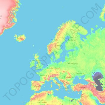
Name: Europe topographic map, elevation, terrain.
Location: Europe (26.00000 -15.00000 76.00000 35.00000)
Average elevation: 223 m
Minimum elevation: -30 m
Maximum elevation: 3,987 m
Make a donation
Other topographic maps
Click on a map to view its topography, its elevation and its terrain.
Nigeria
Nigeria's most expansive topographical region is that of the valleys of the Niger and Benue river valleys (which merge and form a Y-shape). To the southwest of the Niger is a "rugged" highland. To the southeast of the Benue are hills and mountains, which form the Mambilla Plateau, the highest plateau in…
Average elevation: 347 m
Make a donation
Monaco
The four traditional quartiers of Monaco are Monaco-Ville, La Condamine, Monte Carlo and Fontvieille. However, the suburb of Moneghetti, the high-level part of La Condamine, is generally seen today as an effective fifth Quartier of Monaco, having a very distinct atmosphere and topography when compared with…
Average elevation: 105 m
Make a donation
Make a donation
Make a donation
Make a donation
Make a donation
Make a donation
Cross River State
Like few other Nigerian states, the climate of Cross River state is tropical. Not only this, the state is also characterized by relative humidity. The average temperature of the state is between 15°C and 30°C. However, this climatic condition is different in locations within the Cross River state such as the…
Average elevation: 173 m
Make a donation
Make a donation
Central Business District
Nigeria > Federal Capital Territory > Municipal Area Council
Average elevation: 494 m
Make a donation
Make a donation
Make a donation
Odukpani
Odukpani is a Local Government Area (LGA) in Cross River State, South-South Nigeria. It lies between latitude 5°4'52.46''N and longitude 8°20'59.7''E and has an elevation approximately 413 ft. It shares a boundary with Calabar (the state capital) and is largely populated by the Efik people.
Average elevation: 55 m
Make a donation
Make a donation
Mobile
United States > Alabama > Mobile County
According to the United States Census Bureau, the city has a total area of 180.1 square miles (466 km2), with 139.5 square miles (361 km2) of it being land, and 40.6 square miles (105.2 km2), or 22.5% of the total, being covered by water. The elevation in Mobile ranges from 10 feet (3 m) on Water Street in…
Average elevation: 16 m
Biu
Biu is a town and a Local Government Area (LGA) in southern Borno State of Nigeria. The town is the administrative center of the LGA and was once the capital of the Biu kingdom, and is now capital of the Biu Emirate. Biu lies on the Biu Plateau at an average elevation of 626 meters. The region is semi-arid.
Average elevation: 506 m
Make a donation
Make a donation
United Kingdom
Most of the United Kingdom has a temperate climate, with generally cool temperatures and plentiful rainfall all year round. The temperature varies with the seasons seldom dropping below 0 °C (32 °F) or rising above 30 °C (86 °F). Some parts, away from the coast, of upland England, Wales, Northern Ireland…
Average elevation: 42 m
Make a donation
Eastern Obolo
The climate at Obolo, which has an elevation of None meters (0 feet) above sea level, is classified as tropical wet and dry or savanna (Aw). The district's average annual temperature is -0.81% lower than Nigeria's averages at 28.65 °C (83.57 °F). Obolo generally experiences 195.31 wet days (53.51% of the…
Average elevation: 5 m
Make a donation
Make a donation
Make a donation
Make a donation
Ondo State
Nicknamed the "Sunshine State", Ondo State is the 19th most populated state in the country, and the 25th-largest state by landmass. The state is predominantly Yoruba, and the Yoruba language is commonly spoken. The state economy is dominated by the petroleum industry. Cocoa production, asphalt mining, and…
Average elevation: 154 m
Osun State
The climate of Osun is tropical savanna usually warm, with a wet and dry season. It has a yearly average temperature of 64 °F and receives approximately 596 inches of rainfall. It is dry for 59 days throughout the year, with an average moisture in the air of 77% and a UV index of 7. Located at an elevation of…
Average elevation: 285 m
Edo State
Edo state has a Tropical wet and dry or savanna climate with yearly temperature of 28.78 °C (83.8 °F) and it is -0.68% lower than Nigeria's averages. Edo typically receives about 183.49 millimeters (7.22 inches) of precipitation and has 265.91 rainy days (72.85% of the time) annually and at an elevation of…
Average elevation: 140 m
Make a donation
Woodhall Spa
United Kingdom > England > Lincolnshire > East Lindsey > Woodhall Spa
Average elevation: 9 m
Tbilisi
Most of the raions are named after historic quarters of the city. The citizens of Tbilisi widely recognize an informal system of smaller historic neighborhoods. Such neighborhoods are several, however, constituting a kind of hierarchy, because most of them have lost their distinctive topographic limits. The…
Average elevation: 756 m
Make a donation
Philippines
Its highest mountain is Mount Apo on Mindanao, with an altitude of 2,954 meters (9,692 ft) above sea level. The Philippines' longest river is the Cagayan River in northern Luzon, which flows for about 520 kilometers (320 mi). Manila Bay, on which is the capital city of Manila, is connected to Laguna de Bay…
Average elevation: 33 m
Bosnia and Herzegovina
Overall, nearly 50% of Bosnia and Herzegovina is forested. Most forest areas are in the centre, east and west parts of Bosnia. Herzegovina has a drier Mediterranean climate, with dominant karst topography. Northern Bosnia (Posavina) contains very fertile agricultural land along the Sava river and the…
Average elevation: 534 m
Slovenia
The term "Karst topography" refers to that of southwestern Slovenia's Karst Plateau, a limestone region of underground rivers, gorges, and caves, between Ljubljana and the Mediterranean Sea. On the Pannonian plain to the East and Northeast, toward the Croatian and Hungarian borders, the landscape is…
Average elevation: 567 m
Make a donation
Croatia
The territory covers 56,594 square kilometres (21,851 square miles), consisting of 56,414 square kilometres (21,782 square miles) of land and 128 square kilometres (49 square miles) of water. It is the world's 127th largest country. Elevation ranges from the mountains of the Dinaric Alps with the highest point…
Average elevation: 323 m
Hungary
Average elevation: 259 m
Make a donation