
Sri Lanka topographic map
Interactive map
Click on the map to display elevation.
Sri Lanka
Sri Lanka's topography is characterized by a diverse landscape that includes the Central Highlands, plains, and coastal regions. The Central Highlands, located in the south-central part of the island, form its rugged heartland, with the highest peak, Pidurutalagala, reaching 2,524 meters (8,281 feet). This area features a high plateau running north–south for approximately 65 kilometers (40 miles), with mountain ranges extending toward notable peaks like Adam's Peak (2,243 meters or 7,359 feet) and Namunukula (2,036 meters or 6,680 feet). Flanking these central ridges are lower plateaus such as the Hatton Plateau to the west and the Uva Basin to the east, characterized by rolling hills and deep valleys. Descending from the highlands, the terrain transitions into plains that range between 30 and 200 meters (98 to 656 feet) above sea level, with the southwestern plains displaying a dissected appearance due to gradual merging with the Central Highlands. The coastal belt encircles the island and features scenic sandy beaches, coastal lagoons, and, in certain areas like the northeast and southwest, rocky cliffs and bays formed by crystalline rock stratification.
About this map
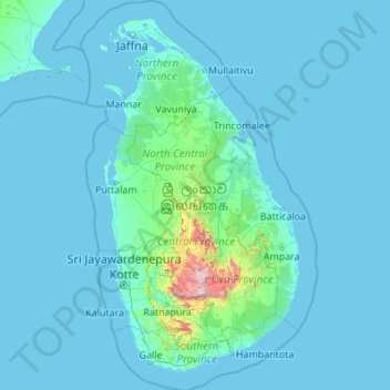
Name: Sri Lanka topographic map, elevation, terrain.
Location: Sri Lanka (5.71900 79.42199 10.03500 82.08101)
Average elevation: 50 m
Minimum elevation: -2 m
Maximum elevation: 2,379 m
Other topographic maps
Click on a map to view its topography, its elevation and its terrain.
Skinnies Lake
United States > Michigan > Marquette County > Humboldt Township
Average elevation: 453 m
Ђаловића клисура
Serbia > Central Serbia > Zlatibor Administrative District > Sjenica Municipality > Crvsko
Average elevation: 1,091 m
Africa
Average elevation: 462 m
Fouta Djallon
Guinea > Mamou Region > Pita Prefecture
Fouta-Djallon consists mainly of rolling grasslands, at an average elevation of about 900 m (3,000 ft). The highest point, Mount Loura, rises to 1,515 m (4,970 ft). The plateau consists of thick sandstone formations that overlie granitic basement rock. Erosion by rain and rivers has carved deep jungle canyons…
Average elevation: 1,143 m
Erickson
Canada > British Columbia > Regional District of Central Kootenay > Area B (Goat River Valley)
Average elevation: 680 m
Erg Chech
It is an almost uninhabited part of the greater Sahara Desert, an inhospitable desert region with long, extremely hot summers and short, very warm winters. The Erg Chech is a vast sandy expanse including compound and complex linear and star dunes. The mean elevation of the Erg Chech is just above 300 m,…
Average elevation: 335 m
Mount Rainier
United States > Washington > Pierce County
Mount Rainier (/reɪˈnɪər/ ray-NEER), also known as Tahoma, is a large active stratovolcano in the Cascade Range of the Pacific Northwest in the United States. The mountain is located in Mount Rainier National Park about 59 miles (95 km) south-southeast of Seattle. With an officially recognized summit…
Average elevation: 3,911 m
Mount Nimba Strict Nature Reserve
Guinea > Nzérékoré Region > Lola Prefecture
The Nimba Range has a sub-equatorial montane climate. Temperature changes extremely with altitude, with a daytime maximum ranging between 24 °C and 33 °C, and the nightly minimum can fall below 10 °C. Some parts of the reserve receive significantly less precipitation, due to rain-shadow effect of the high…
Average elevation: 657 m
Kharagpur
India > West Bengal > Kharagpur-I
Kharagpur is the fourth largest city of West Bengal in area after Kolkata, Durgapur and Asansol. It is also the fifth most populated city of West Bengal after Kolkata, Asansol, Siliguri, Durgapur - located at 22°19′49″N 87°19′25″E / 22.330239°N 87.323653°E / 22.330239; 87.323653, covering…
Average elevation: 39 m
Agodi gate water corporation
Nigeria > Oyo State > Ibadan North East > Ibadan
Average elevation: 228 m
Ponticelli
Ponticelli is a frazione of the comune of Città della Pieve in the Province of Perugia, Umbria, central Italy. It stands at an elevation of 249 metres above sea level. At the time of the Istat census of 2001 it had 610 inhabitants.
Average elevation: 275 m
Ngong
Kenya > Kajiado County > Kajiado North > Ngong ward
As of 2019, the population of Ngong Town consisting of Enchorro-Emunyi and Ngong Township locations was 25,866. The elevation of Ngong Town is 1,961 meters in altitude, but the altitude of the hills is about 2,460 meters above sea level. Ngong was the central town of Ngong division when Kajiado County was a…
Average elevation: 1,951 m
Nestor Falls
Canada > Ontario > Kenora District > Sioux Narrows-Nestor Falls Township
Average elevation: 337 m