
Ukraine topographic map
Interactive map
Click on the map to display elevation.
About this map
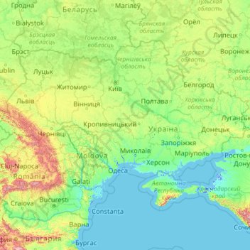
Name: Ukraine topographic map, elevation, terrain.
Location: Ukraine (44.18460 22.13706 52.37975 40.22781)
Average elevation: 183 m
Minimum elevation: -5 m
Maximum elevation: 2,993 m
The landscape of Ukraine consists mostly of fertile plains (or steppes) and plateaus, crossed by rivers such as the Dnieper (Dnipro), Seversky Donets, Dniester and the Southern Bug as they flow south into the Black Sea and the smaller Sea of Azov. To the southwest, the delta of the Danube forms the border with Romania. Ukraine's various regions have diverse geographic features ranging from the highlands to the lowlands. The country's only mountains are the Carpathian Mountains in the west, of which the highest is the Hora Hoverla at 2,061 metres (6,762 ft), and the Crimean Mountains on Crimea, in the extreme south along the coast. However Ukraine also has a number of highland regions such as the Volyn-Podillia Upland (in the west) and the Near-Dnipro Upland (on the right bank of Dnieper); to the east there are the south-western spurs of the Central Russian Upland over which runs the border with the Russian Federation. Near the Sea of Azov can be found the Donets Ridge and the Near Azov Upland. The snow melt from the mountains feeds the rivers, and natural changes in altitude form sudden drops in elevation and give rise to waterfalls.
Other topographic maps
Click on a map to view its topography, its elevation and its terrain.
Mobile
United States > Alabama > Mobile County
Mobile, Mobile County, Alabama, United States
Average elevation: 18 m
Joensuu
Joensuu, Joensuu sub-region, North Karelia, Regional State Administrative Agency for Eastern Finland, Mainland Finland, Finland
Average elevation: 113 m
Lagos
Nigeria > Lagos State > Lagos Island
Lagos, Lagos Island, Lagos State, 100242, Nigeria
Average elevation: 5 m
Buggenhout
Belgium > East Flanders > Dendermonde
Buggenhout, Dendermonde, East Flanders, Flanders, 9255, Belgium
Average elevation: 12 m
Bangor
United Kingdom > Northern Ireland > County Down
Bangor, County Down, Northern Ireland, BT20 5AG, United Kingdom
Average elevation: 40 m
Kilcolgan
Kilcolgan, Drumacoo ED, Loughrea Municipal District, County Galway, Connacht, Ireland
Average elevation: 11 m
Newcastle upon Tyne
Newcastle upon Tyne, North of Tyne, England, United Kingdom
Average elevation: 57 m
Oju Ota
Nigeria > Ogun State > Yewa South
Oju Ota, Yewa South, Ogun State, Nigeria
Average elevation: 40 m
Sewell
Chile > O'Higgins Region > Provincia de Cachapoal > Machalí
Sewell, Machalí, Provincia de Cachapoal, O'Higgins Region, Chile
Average elevation: 2,480 m
Mauritius
Mauritius
Average elevation: 0 m
Jim Edgar Panther Creek State Fish and Wildlife Area
United States > Illinois > Cass County
Jim Edgar Panther Creek State Fish and Wildlife Area, 10149, Cass County, Illinois, 62627, United States
Average elevation: 183 m
Villandry
France > Centre-Val de Loire > Indre-et-Loire
Villandry, Tours, Indre-et-Loire, Centre-Val de Loire, Metropolitan France, 37510, France
Average elevation: 70 m
Buenos Aires
Argentina > Autonomous City of Buenos Aires
Buenos Aires, Comuna 1, Autonomous City of Buenos Aires, Argentina
Average elevation: 9 m
Zurndorf
Austria > Burgenland > Bezirk Neusiedl am See
Zurndorf, Bezirk Neusiedl am See, Burgenland, 2424, Austria
Average elevation: 150 m
Bahía Blanca
Bahía Blanca, Partido de Bahía Blanca, Buenos Aires, Argentina
Average elevation: 37 m
Port Arthur
Port Arthur, Tasman, Tasmania, 7182, Australia
Average elevation: 153 m
Priozersk
Russia > Leningrad oblast > Käkisalmi District
Priozersk, Приозерское городское поселение, Käkisalmi District, Leningrad oblast, Northwestern Federal District, 188760, Russia
Average elevation: 12 m
Double Tree
United States > Alabama > Madison County > Huntsville
Double Tree, Huntsville, Madison County, Alabama, 35802, United States
Average elevation: 263 m
Copenhagen
Denmark > Capital Region of Denmark
Copenhagen, Copenhagen Municipality, Capital Region of Denmark, 1357, Denmark
Average elevation: 9 m
Huntsville
United States > Alabama > Madison County
Huntsville, Madison County, Alabama, United States
Average elevation: 232 m
Madurai
India > Tamil Nadu > Madurai South
Madurai, Madurai South, Madurai District, Tamil Nadu, India
Average elevation: 137 m
Cardiff
United Kingdom > Wales > Cardiff
Cardiff, Wales, CF10 2AF, United Kingdom
Average elevation: 55 m
Itere
Nigeria > Ogun State > Ado Odo/Ota
Itere, Ado Odo/Ota, Ogun State, Nigeria
Average elevation: 7 m
Kara-Kulja
Kyrgyzstan > Osh Region > Kara-Kulja District
Kara-Kulja, Kara-Kulja District, Osh Region, Kyrgyzstan
Average elevation: 1,443 m
Ashaka
Nigeria > Gombe State > Funakaye
Ashaka, Funakaye, Gombe State, Nigeria
Average elevation: 260 m
Bukura
Kenya > Kakamega County > Butere
Bukura, Butere, Kakamega County, Western, Kenya
Average elevation: 1,434 m
Dhaka
Dhaka, Dhaka Metropolitan, Dhaka District, Dhaka Division, 1215, Bangladesh
Average elevation: 7 m
Denmark
Denmark
Average elevation: 30 m
Canada
Canada
Average elevation: 254 m
Village of Arcade
United States > New York > Wyoming County
Village of Arcade, Town of Arcade, Wyoming County, New York, United States
Average elevation: 478 m