Geolocate

Sri Lanka topographic map

Click on the map to display elevation.

Sri Lanka

Sri Lanka's topography is characterized by a diverse landscape that includes the Central Highlands, plains, and coastal regions. The Central Highlands, located in the south-central part of the island, form its rugged heartland, with the highest peak, Pidurutalagala, reaching 2,524 meters (8,281 feet). This area features a high plateau running north–south for approximately 65 kilometers (40 miles), with mountain ranges extending toward notable peaks like Adam's Peak (2,243 meters or 7,359 feet) and Namunukula (2,036 meters or 6,680 feet). Flanking these central ridges are lower plateaus such as the Hatton Plateau to the west and the Uva Basin to the east, characterized by rolling hills and deep valleys. Descending from the highlands, the terrain transitions into plains that range between 30 and 200 meters (98 to 656 feet) above sea level, with the southwestern plains displaying a dissected appearance due to gradual merging with the Central Highlands. The coastal belt encircles the island and features scenic sandy beaches, coastal lagoons, and, in certain areas like the northeast and southwest, rocky cliffs and bays formed by crystalline rock stratification.

About this map

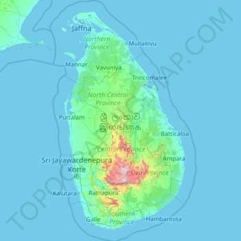
Name: Sri Lanka topographic map, elevation, terrain.

Location: Sri Lanka (5.71900 79.42199 10.03500 82.08101)

Average elevation: 50 m

Minimum elevation: -2 m

Maximum elevation: 2,379 m

Other topographic maps

Click on a map to view its topography, its elevation and its terrain.

Derby

United Kingdom > England > Derbyshire

Average elevation: 96 m

Baidi

China > Chongqing > Fengjie County

Average elevation: 436 m

Deru

Indonesia > East Java > Bojonegoro

Average elevation: 25 m

Lagos

Nigeria > Lagos State > Lagos Island

Average elevation: 5 m

Buurhakaba

Somalia > Bay > Burhakaba District

Burhakaba is situated at the coordinates of 2.7991° N, 44.0794° E with an elevation of 196 meters above sea level. It lacks a permanent river, but it does have a large valley known as "Bohol Wiinti" that runs through the town from the north, east, and south-east. After seasonal rainfall, the valley supports…

Average elevation: 203 m

West Amesbury

United Kingdom > England > Wiltshire

Average elevation: 90 m

Munhaye

Nigeria > Zamfara State > Tsafe > Danjibga

Average elevation: 629 m

Aalborg

Denmark > North Denmark Region

The area close to the waterfront is low-lying, with an elevation averaging about 5 metres (16 ft), but there are many hills in and around city, some reaching over 60 m (200 ft). Nørresundby, on the northern side of the sound, is also a hilly area. Villages to the south of Aalborg from west to east include…

Average elevation: 17 m

Ethiopian Highlands

Ethiopia > Amhara Region

Average elevation: 4,164 m

Hayy al-Auropa

Iraq > Nineveh Governorate > Mosul

Average elevation: 253 m

Alexandria

Egypt > Alexandria

Average elevation: 0 m

Owerri

Nigeria > Imo State > Owerri Municipal

Average elevation: 88 m

Sungai Bekok

Malaysia > Johor

Average elevation: 77 m

Sant'Ilario

Italy > Tuscany > Livorno

Average elevation: 222 m

Zliten

Libya > Bani Walid

Average elevation: 35 m

Ijare

Nigeria > Ondo State > Ifedore

Average elevation: 409 m

Rothwell

United Kingdom > England > Leeds

Average elevation: 54 m

Saribu Dolok

Indonesia > North Sumatra > Simalungun

Average elevation: 1,391 m

Wordsley

United Kingdom > England > Dudley

Average elevation: 98 m

Gemas Baru

Malaysia > Johor

Average elevation: 36 m

York

United Kingdom > England > York

Average elevation: 21 m

Sheladize

Iraq > Duhok Governorate

Average elevation: 734 m

Ören

Turkey > Bartın

Average elevation: 739 m

Ören

Turkey > Milas

Average elevation: 99 m

Wiesengiech

Germany > Bavaria > Landkreis Bamberg > Scheßlitz

Average elevation: 305 m

Riparius

United States > New York > Warren County

Average elevation: 334 m

Bursa

Turkey > Osmangazi

Average elevation: 598 m

Mamanaca

Bolivia > Cochabamba > Esteban Arze

Average elevation: 2,764 m

Derry/Londonderry

United Kingdom > Northern Ireland > County Londonderry

Derry is characterised by its distinctively hilly topography. The River Foyle forms a deep valley as it flows through the city, giving it a steep topography. The original walled city of Londonderry lies on a hill on the west bank of the River Foyle. In the past, the river branched and enclosed this hill as an…

Average elevation: 88 m

Mbeya

Tanzania > Mbeya Region

Mbeya is situated at an altitude of 1,700 metres (5,500 ft), and sprawls through a narrow highland valley surrounded by a bowl of high mountains. The main language is colloquial Swahili, and the English language is extensively taught in schools.

Average elevation: 1,817 m

Bokod

Philippines > Benguet

Average elevation: 1,244 m

Noceto Sottano

Italy > Piedmont > Cuneo > Monesiglio

Average elevation: 578 m

Črnuški bajer

Slovenia > Ljubljana

Average elevation: 314 m

Malabe

Sri Lanka > Western Province

Average elevation: 15 m

Wishart

Canada > Saskatchewan > Emerald No. 277

Average elevation: 625 m

Lima

Peru > Lima

The suburban district of Cieneguilla, the district of Pachacámac and the district of Chosica provide important tourist attractions among locals. Due to its elevation (over 500 masl), the sun shines in Chosica during the winter, being very visited by the residents of Lima to escape the urban fog.

Average elevation: 236 m

Chitungwiza

Zimbabwe > Harare > Harare

Average elevation: 1,438 m

Scafell Pike

United Kingdom > England > Cumberland

Scafell Pike (/ˈskɔːfɛl/) is a hill in the Lake District region of Cumbria, England. It has an elevation of 978 metres (3,209 ft) above sea level, making it the highest and the most prominent mountain in England. The mountain is part of the Scafell massif, an extinct volcano, and is one of the Southern Fells.

Average elevation: 679 m

Famolasco

Italy > Piedmont > Turin

Average elevation: 508 m

Enoshima

Japan > Fujisawa

Average elevation: 2 m

Snowdon

United Kingdom > Wales > Gwynedd

Snowdon (/ˈsnoʊdən/), or Yr Wyddfa (Welsh: [ər ˈʊɨ̞̯ðva] ), is a mountain in Snowdonia in North Wales. It has an elevation of 1,085 metres (3,560 ft) above sea level, which makes it both the highest mountain in Wales and the highest in the British Isles south of the Scottish Highlands. Snowdon is…

Average elevation: 692 m

Ciampanesio

Italy > Piedmont > Cuneo > Sampeyre

Average elevation: 1,604 m

Eifel

Germany > Rhineland-Palatinate > Landkreis Ahrweiler > Adenau

The Eifel is in the Atlantic climate zone with its relatively high precipitation; winters that are moderately cold and long with periods of snow; and summers that are often humid and cool. The prevailing wind is west/southwest. A relatively dry and milder climate prevails in the wind and rain shadow of the…

Average elevation: 585 m

Akiri

Gabon > Ogooué-Maritime Province > Bengué

Average elevation: 9 m

Ahmar Mountains

Ethiopia > Oromia Region

Average elevation: 1,777 m

Zaria

Nigeria > Kaduna State > Sabon Gari

Average elevation: 655 m

Castlewellan

United Kingdom > Northern Ireland

Average elevation: 104 m

Kakkera

India > Karnataka > Shorapur

Average elevation: 409 m

Eruwa

Nigeria > Oyo State > Ibarapa East

Average elevation: 149 m

Valmala

Italy > Piedmont > Cuneo > Busca

Average elevation: 995 m

Nature's Valley

South Africa > Western Cape > George

Average elevation: 69 m

Dammam

Saudi Arabia > Eastern Province

Average elevation: 9 m

Atulayan Norte

Philippines > Cagayan > Tuguegarao

Average elevation: 22 m

Akhmim

Egypt > Suhaj

Average elevation: 62 m

Chityala

India > Telangana > Wanaparthy mandal

Average elevation: 397 m

Memari

India > West Bengal > Memari - I

Memari is located at 23°12′N 88°07′E / 23.2°N 88.12°E / 23.2; 88.12. It has an average elevation of 25 metres (82 feet).

Average elevation: 21 m

Broadstairs

United Kingdom > England > Kent > Thanet

Average elevation: 14 m

Marlieu

France > Auvergne-Rhône-Alpes > Ain > Talissieu

Average elevation: 339 m

Abuja

Nigeria > Federal Capital Territory > Municipal Area Council

The elevation is 360 metres (1,180 ft).

Average elevation: 508 m

Fucine

Italy > Piedmont > Torino

Average elevation: 907 m

Tarmac Malete Ilorin

Nigeria > Kwara State > Moro

Average elevation: 334 m

Bori

Nigeria > Rivers State > Khana

Average elevation: 15 m

Pisan

Philippines > North Cotabato > Kabacan

Average elevation: 54 m

Ankara

Turkey > Ankara > Çankaya

Ankara has a cold semi-arid climate under the Köppen climate classification (BSk), while under the Trewartha climate classification, the city is classified as humid continental (Dc). Due to its elevation and inland location, Ankara has cold and snowy winters, and hot and dry summers. Rainfall occurs mostly…

Average elevation: 1,082 m

Homlung

Norway > Møre og Romsdal > Geiranger

Average elevation: 513 m

Borgo di Valcasotto

Italy > Piedmont > Cuneo > Pamparato

Average elevation: 1,223 m

Kozhikode

India > Kerala > Kozhikode

Average elevation: 14 m

Europe

In general, Europe is not just colder towards the north compared to the south, but it also gets colder from the west towards the east. The climate is more oceanic in the west and less so in the east. This can be illustrated by the following table of average temperatures at locations roughly following the 64th,…

Average elevation: 223 m

Bassa

Italy > Tuscany > Florence > Cerreto Guidi

Average elevation: 35 m

San Lazzaro Reale

Italy > Liguria > Provincia di Imperia

Average elevation: 372 m

Bøyabreen

Norway > Vestland

Average elevation: 553 m

Bosso

Niger > Diffa Region > Diffa

Average elevation: 283 m

Longsha

China > Heilongjiang

Average elevation: 148 m

Liveglia

Italy > Emilia-Romagna > Parma > Bedonia

Average elevation: 1,037 m

Chiang Dao

Thailand > Chiang Dao

Average elevation: 433 m

Sugar Island

United States > Maine > Piscataquis County

Average elevation: 337 m

Antalya

Turkey > Muratpaşa

While the city itself only has modest elevation changes, Antalya has high mountains in all directions to its interior. With moisture being trapped, the local climate thus has high winter rainfall, while the interior bay setting results in very hot summers for a coastal city.

Average elevation: 117 m

Derai

Pakistan > Khyber Pakhtunkhwa > Lower Dir District

Average elevation: 1,290 m

Hasty

United States > Arkansas > Newton County

Average elevation: 337 m

Whitt

United States > Texas > Parker County

Average elevation: 339 m

Nickel Lake

Canada > Ontario > Sudbury District > Greater Sudbury

Average elevation: 399 m

Baraigram

India > Assam > Nilambazar

Average elevation: 21 m

Futa

Turkey > Kozlu

Average elevation: 459 m

Khandwa

India > Madhya Pradesh > Khandwa Nagar Tahsil

Khandwa is located at 21°50′N 76°20′E / 21.83°N 76.33°E / 21.83; 76.33. It has an average elevation of 313 metres (1026 feet).

Average elevation: 325 m