
Saudi Arabia topographic map
Interactive map
Click on the map to display elevation.
About this map
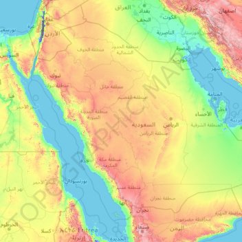
Name: Saudi Arabia topographic map, elevation, terrain.
Location: Saudi Arabia (16.29000 34.45717 32.15428 55.66669)
Average elevation: 551 m
Minimum elevation: -415 m
Maximum elevation: 3,894 m
Saudi Arabia's diverse geography is dominated by the Arabian Desert, associated semi-desert, shrubland, steppes, several mountain ranges, volcanic lava fields and highlands. The 647,500 km2 (250,001 sq mi) Rub' al Khali ("Empty Quarter") in the southeastern part of the country is the world's largest contiguous sand desert. Though there are lakes in the country, Saudi Arabia is the largest country in the world by area with no permanent rivers. Wadis, non-permanent rivers, however, are very numerous. The fertile areas are to be found in the alluvial deposits in wadis, basins, and oases. The main topographical feature is the central plateau which rises abruptly from the Red Sea and gradually descends into the Nejd and toward the Persian Gulf. On the Red Sea coast, there is a narrow coastal plain, known as the Tihamah parallel to which runs an imposing escarpment. The southwest province of Asir is mountainous, and contains the 3,133 m (10,279 ft) Mount Sawda, which is the highest point in the country. Saudi Arabia is home to more than 2000 dormant volcanoes. Lava fields in Hejaz, known locally by their Arabic name of harrat (the singular is harrah), form one of Earth's largest alkali basalt regions, covering some 180,000 square kilometres (69,000 sq mi), an area greater than the state of Missouri.
Other topographic maps
Click on a map to view its topography, its elevation and its terrain.
Mwanza
Mwanza, Nyamagana, Mwanza Region, Lake Zone, 33214, Tanzania
Average elevation: 1,178 m
Atyrau
Kazakhstan > Atyrau Region > Атырау қалалық әкімдігі
Atyrau, Атырау қалалық әкімдігі, Atyrau Region, 060000, Kazakhstan
Average elevation: -22 m
Қазақстан
Kazakhstan > Turkistan Region > Keles District > Бірлесу ауылдық округі
Қазақстан, Бірлесу ауылдық округі, Keles District, Turkistan Region, Kazakhstan
Average elevation: 314 m
Mobile
United States > Alabama > Mobile County
Mobile, Mobile County, Alabama, United States
Average elevation: 18 m
Dartmoor National Park
United Kingdom > England > Devon
Dartmoor National Park, Devon, England, United Kingdom
Average elevation: 239 m
Barshijora Eco-Park
Bangladesh > Sylhet Division > Kamalganj Upazila
Barshijora Eco-Park, Kamalganj Upazila, Moulvibazar District, Sylhet Division, Bangladesh
Average elevation: 25 m
Gembu
Nigeria > Taraba State > Sardauna
Gembu, Sardauna, Taraba State, Nigeria
Average elevation: 1,484 m
Joensuu
Joensuu, Joensuu sub-region, North Karelia, Regional State Administrative Agency for Eastern Finland, Mainland Finland, Finland
Average elevation: 113 m
Banshkhali
Bangladesh > Chattogram Division
Banshkhali, Chattogram District, Chattogram Division, 4393, Bangladesh
Average elevation: 11 m
Lagos
Nigeria > Lagos State > Lagos Island
Lagos, Lagos Island, Lagos State, 100242, Nigeria
Average elevation: 5 m
Brecon Beacons National Park
United Kingdom > Wales > Powys
Brecon Beacons National Park, Powys, Wales, United Kingdom
Average elevation: 270 m
Rajeshpur Eco-Park
Bangladesh > Chattogram Division > Cumilla Adarsha Sadar Upazila
Rajeshpur Eco-Park, Cumilla Adarsha Sadar Upazila, Cumilla District, Chattogram Division, Bangladesh
Average elevation: 15 m
Sylhet
Bangladesh > Sylhet Division > Sylhet Sadar Upazila
Sylhet, Sylhet Sadar Upazila, Sylhet District, Sylhet Division, 3100, Bangladesh
Average elevation: 14 m
Sitakunda
Bangladesh > Chattogram Division > Sitakunda Upazila
Sitakunda, Sitakunda Upazila, Chattogram District, Chattogram Division, Bangladesh
Average elevation: 40 m
Kilcolgan
Kilcolgan, Drumacoo ED, Loughrea Municipal District, County Galway, Connacht, Ireland
Average elevation: 11 m
Buggenhout
Belgium > East Flanders > Dendermonde
Buggenhout, Dendermonde, East Flanders, Flanders, 9255, Belgium
Average elevation: 12 m
Newcastle upon Tyne
Newcastle upon Tyne, North of Tyne, England, United Kingdom
Average elevation: 57 m
Bahía Blanca
Bahía Blanca, Partido de Bahía Blanca, Buenos Aires, Argentina
Average elevation: 37 m
Bangor
United Kingdom > Northern Ireland > County Down
Bangor, County Down, Northern Ireland, BT20 5AG, United Kingdom
Average elevation: 40 m
Mauritius
Mauritius
Average elevation: 0 m
Oju Ota
Nigeria > Ogun State > Yewa South
Oju Ota, Yewa South, Ogun State, Nigeria
Average elevation: 40 m
Priozersk
Russia > Leningrad oblast > Käkisalmi District
Priozersk, Приозерское городское поселение, Käkisalmi District, Leningrad oblast, Northwestern Federal District, 188760, Russia
Average elevation: 12 m
Sewell
Chile > O'Higgins Region > Provincia de Cachapoal > Machalí
Sewell, Machalí, Provincia de Cachapoal, O'Higgins Region, Chile
Average elevation: 2,480 m
Huntsville
United States > Alabama > Madison County
Huntsville, Madison County, Alabama, United States
Average elevation: 232 m
Buenos Aires
Argentina > Autonomous City of Buenos Aires
Buenos Aires, Comuna 1, Autonomous City of Buenos Aires, Argentina
Average elevation: 9 m
Port Arthur
Port Arthur, Tasman, Tasmania, 7182, Australia
Average elevation: 153 m
Itere
Nigeria > Ogun State > Ado Odo/Ota
Itere, Ado Odo/Ota, Ogun State, Nigeria
Average elevation: 7 m
Kara-Kulja
Kyrgyzstan > Osh Region > Kara-Kulja District
Kara-Kulja, Kara-Kulja District, Osh Region, Kyrgyzstan
Average elevation: 1,443 m
Villandry
France > Centre-Val de Loire > Indre-et-Loire
Villandry, Tours, Indre-et-Loire, Centre-Val de Loire, Metropolitan France, 37510, France
Average elevation: 70 m
Dhaka
Dhaka, Dhaka Metropolitan, Dhaka District, Dhaka Division, 1215, Bangladesh
Average elevation: 7 m