
Colombia topographic map
Interactive map
Click on the map to display elevation.
About this map
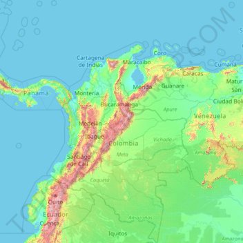
Name: Colombia topographic map, elevation, terrain.
Location: Colombia (-4.22940 -82.12436 16.04955 -66.84904)
Average elevation: 248 m
Minimum elevation: -2 m
Maximum elevation: 5,809 m
Mountain climate is one of the unique features of the Andes and other high altitude reliefs where climate is determined by elevation. Below 1,000 meters (3,281 ft) in elevation is the warm altitudinal zone, where temperatures are above 24 °C (75.2 °F). About 82.5% of the country's total area lies in the warm altitudinal zone. The temperate climate altitudinal zone located between 1,001 and 2,000 meters (3,284 and 6,562 ft) is characterized for presenting an average temperature ranging between 17 and 24 °C (62.6 and 75.2 °F). The cold climate is present between 2,001 and 3,000 meters (6,565 and 9,843 ft) and the temperatures vary between 12 and 17 °C (53.6 and 62.6 °F). Beyond lies the alpine conditions of the forested zone and then the treeless grasslands of the páramos. Above 4,000 meters (13,123 ft), where temperatures are below freezing, the climate is glacial, a zone of permanent snow and ice.
Other topographic maps
Click on a map to view its topography, its elevation and its terrain.
Mobile
United States > Alabama > Mobile County
Mobile, Mobile County, Alabama, United States
Average elevation: 18 m
Dartmoor National Park
United Kingdom > England > Devon
Dartmoor National Park, Devon, England, United Kingdom
Average elevation: 239 m
Lagos
Nigeria > Lagos State > Lagos Island
Lagos, Lagos Island, Lagos State, 100242, Nigeria
Average elevation: 5 m
Brecon Beacons National Park
United Kingdom > Wales > Powys
Brecon Beacons National Park, Powys, Wales, United Kingdom
Average elevation: 270 m
Gembu
Nigeria > Taraba State > Sardauna
Gembu, Sardauna, Taraba State, Nigeria
Average elevation: 1,484 m
Rajeshpur Eco-Park
Bangladesh > Chattogram Division > Cumilla Adarsha Sadar Upazila
Rajeshpur Eco-Park, Cumilla Adarsha Sadar Upazila, Cumilla District, Chattogram Division, Bangladesh
Average elevation: 15 m
Barshijora Eco-Park
Bangladesh > Sylhet Division > Kamalganj Upazila
Barshijora Eco-Park, Kamalganj Upazila, Moulvibazar District, Sylhet Division, Bangladesh
Average elevation: 25 m
Joensuu
Joensuu, Joensuu sub-region, North Karelia, Regional State Administrative Agency for Eastern Finland, Mainland Finland, Finland
Average elevation: 113 m
Banshkhali
Bangladesh > Chattogram Division
Banshkhali, Chattogram District, Chattogram Division, 4393, Bangladesh
Average elevation: 11 m
Sylhet
Bangladesh > Sylhet Division > Sylhet Sadar Upazila
Sylhet, Sylhet Sadar Upazila, Sylhet District, Sylhet Division, 3100, Bangladesh
Average elevation: 14 m
Sitakunda
Bangladesh > Chattogram Division > Sitakunda Upazila
Sitakunda, Sitakunda Upazila, Chattogram District, Chattogram Division, Bangladesh
Average elevation: 40 m
Kilcolgan
Kilcolgan, Drumacoo ED, Loughrea Municipal District, County Galway, Connacht, Ireland
Average elevation: 11 m
Buggenhout
Belgium > East Flanders > Dendermonde
Buggenhout, Dendermonde, East Flanders, Flanders, 9255, Belgium
Average elevation: 12 m
Newcastle upon Tyne
Newcastle upon Tyne, North of Tyne, England, United Kingdom
Average elevation: 57 m
Bangor
United Kingdom > Northern Ireland > County Down
Bangor, County Down, Northern Ireland, BT20 5AG, United Kingdom
Average elevation: 40 m
Mauritius
Mauritius
Average elevation: 0 m
Sewell
Chile > O'Higgins Region > Provincia de Cachapoal > Machalí
Sewell, Machalí, Provincia de Cachapoal, O'Higgins Region, Chile
Average elevation: 2,480 m
Itere
Nigeria > Ogun State > Ado Odo/Ota
Itere, Ado Odo/Ota, Ogun State, Nigeria
Average elevation: 7 m
Kara-Kulja
Kyrgyzstan > Osh Region > Kara-Kulja District
Kara-Kulja, Kara-Kulja District, Osh Region, Kyrgyzstan
Average elevation: 1,443 m
Priozersk
Russia > Leningrad oblast > Käkisalmi District
Priozersk, Приозерское городское поселение, Käkisalmi District, Leningrad oblast, Northwestern Federal District, 188760, Russia
Average elevation: 12 m
Bahía Blanca
Bahía Blanca, Partido de Bahía Blanca, Buenos Aires, Argentina
Average elevation: 37 m
Huntsville
United States > Alabama > Madison County
Huntsville, Madison County, Alabama, United States
Average elevation: 232 m
Oju Ota
Nigeria > Ogun State > Yewa South
Oju Ota, Yewa South, Ogun State, Nigeria
Average elevation: 40 m
Dhaka
Dhaka, Dhaka Metropolitan, Dhaka District, Dhaka Division, 1215, Bangladesh
Average elevation: 7 m
Port Arthur
Port Arthur, Tasman, Tasmania, 7182, Australia
Average elevation: 153 m
Zurndorf
Austria > Burgenland > Bezirk Neusiedl am See
Zurndorf, Bezirk Neusiedl am See, Burgenland, 2424, Austria
Average elevation: 150 m
Copenhagen
Denmark > Capital Region of Denmark
Copenhagen, Copenhagen Municipality, Capital Region of Denmark, 1357, Denmark
Average elevation: 9 m
Jim Edgar Panther Creek State Fish and Wildlife Area
United States > Illinois > Cass County
Jim Edgar Panther Creek State Fish and Wildlife Area, 10149, Cass County, Illinois, 62627, United States
Average elevation: 183 m
Villandry
France > Centre-Val de Loire > Indre-et-Loire
Villandry, Tours, Indre-et-Loire, Centre-Val de Loire, Metropolitan France, 37510, France
Average elevation: 70 m
Buenos Aires
Argentina > Autonomous City of Buenos Aires
Buenos Aires, Comuna 1, Autonomous City of Buenos Aires, Argentina
Average elevation: 9 m