
Make a donation
Spain topographic map
Click on the map to display elevation.
Make a donation
Spain
Mainland Spain is a rather mountainous landmass, dominated by high plateaus and mountain chains. After the Pyrenees, the main mountain ranges are the Cordillera Cantábrica (Cantabrian Range), Sistema Ibérico (Iberian System), Sistema Central (Central System), Montes de Toledo, Sierra Morena and the Sistema Bético (Baetic System) whose highest peak, the 3,478-metre-high (11,411-foot) Mulhacén, located in Sierra Nevada, is the highest elevation in the Iberian Peninsula. The highest point in Spain is the Teide, a 3,718-metre (12,198 ft) active volcano in the Canary Islands. The Meseta Central (often translated as 'Inner Plateau') is a vast plateau in the heart of peninsular Spain split in two by the Sistema Central.
Make a donation
About this map
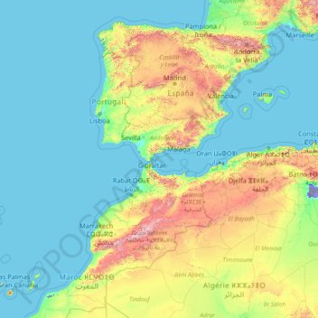
Name: Spain topographic map, elevation, terrain.
Location: Spain (27.43354 -18.39368 43.99331 4.59189)
Average elevation: 331 m
Minimum elevation: -31 m
Maximum elevation: 3,808 m
Make a donation
Other topographic maps
Click on a map to view its topography, its elevation and its terrain.
Make a donation
Make a donation
Make a donation
Jos Plateau
Nigeria > Plateau State > Jos East
It covers 8600 km2 and is bounded by 300–600 m escarpments around much of its boundary. With an average altitude of 1,280 m, it is the largest area over 1,000m in Nigeria, with a high point of 1,776m, in the Shere Hills. Several rivers have their sources on the plateau. The Kaduna River drains the western…
Average elevation: 951 m
Galadimawa Village
Nigeria > Federal Capital Territory > Municipal Area Council
Average elevation: 446 m
Make a donation
Make a donation
Make a donation
Make a donation
Make a donation
Make a donation
Make a donation
Make a donation
Make a donation
Make a donation
Make a donation
Make a donation
Make a donation
Make a donation
Make a donation
Jos
Nigeria > Plateau State > Jos North
At an altitude of 1,217 m (3,993 ft) above sea level, Jos' climate is closer to temperate than that of the vast majority of Nigeria. Average monthly temperatures range from 21–25 °C (70–77 °F), and from mid-November to late January, night-time temperatures drop as low as 7 °C (45 °F). Hail sometimes…
Average elevation: 1,181 m
Make a donation
Make a donation
Make a donation
Make a donation
Make a donation
Make a donation
Make a donation