
Make a donation
Nicaragua topographic map
Click on the map to display elevation.
Make a donation
Nicaragua
Most of the Pacific zone is tierra caliente, the "hot land" of tropical Spanish America at elevations under 610 metres (2,000 ft). Temperatures remain virtually constant throughout the year, with highs ranging between 29.4 and 32.2 °C (85 and 90 °F). After a dry season lasting from November to April, rains begin in May and continue to October, giving the Pacific lowlands 1,016 to 1,524 millimetres (40 to 60 in) of precipitation.
Make a donation
About this map
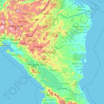
Name: Nicaragua topographic map, elevation, terrain.
Location: Nicaragua (10.70739 -87.89582 15.09028 -82.47672)
Average elevation: 268 m
Minimum elevation: -2 m
Maximum elevation: 2,698 m
Make a donation
Other topographic maps
Click on a map to view its topography, its elevation and its terrain.
Make a donation
Make a donation
Abuja
Nigeria > Federal Capital Territory > Municipal Area Council
The elevation is 360 metres (1,180 ft).
Average elevation: 508 m
Make a donation
Make a donation
Make a donation
Make a donation
Make a donation
Make a donation
Make a donation
Make a donation
Make a donation
Make a donation
Make a donation
Make a donation
Make a donation
Make a donation
Make a donation
Jos
Nigeria > Plateau State > Jos North
At an altitude of 1,217 m (3,993 ft) above sea level, Jos' climate is closer to temperate than that of the vast majority of Nigeria. Average monthly temperatures range from 21–25 °C (70–77 °F), and from mid-November to late January, night-time temperatures drop as low as 7 °C (45 °F). Hail sometimes…
Average elevation: 1,181 m
Make a donation
Make a donation
Make a donation
Make a donation
Make a donation
Make a donation
Make a donation
Make a donation