
Make a donation
Cyprus topographic map
Click on the map to display elevation.
Make a donation
Cyprus
The physical relief of the island is dominated by two mountain ranges, the Troodos Mountains and the smaller Kyrenia Range, and the central plain they encompass, the Mesaoria. The Mesaoria plain is drained by the Pedieos River, the longest on the island. The Troodos Mountains cover most of the southern and western portions of the island and account for roughly half its area. The highest point on Cyprus is Mount Olympus at 1,952 m (6,404 ft), located in the centre of the Troodos range. The narrow Kyrenia Range, extending along the northern coastline, occupies substantially less area, and elevations are lower, reaching a maximum of 1,024 m (3,360 ft). The island lies within the Anatolian Plate.
Make a donation
About this map
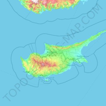
Name: Cyprus topographic map, elevation, terrain.
Location: Cyprus (34.43837 32.02276 35.91325 34.85532)
Average elevation: 73 m
Minimum elevation: -5 m
Maximum elevation: 2,247 m
Make a donation
Other topographic maps
Click on a map to view its topography, its elevation and its terrain.
Make a donation
Make a donation
Jos Plateau
Nigeria > Plateau State > Jos East
It covers 8600 km2 and is bounded by 300–600 m escarpments around much of its boundary. With an average altitude of 1,280 m, it is the largest area over 1,000m in Nigeria, with a high point of 1,776m, in the Shere Hills. Several rivers have their sources on the plateau. The Kaduna River drains the western…
Average elevation: 951 m
Make a donation
Galadimawa Village
Nigeria > Federal Capital Territory > Municipal Area Council
Average elevation: 446 m
Make a donation
Make a donation
Make a donation
Make a donation
Make a donation
Make a donation
Make a donation
Make a donation
Make a donation
Make a donation
Make a donation
Make a donation
Make a donation
Make a donation
Jos
Nigeria > Plateau State > Jos North
At an altitude of 1,217 m (3,993 ft) above sea level, Jos' climate is closer to temperate than that of the vast majority of Nigeria. Average monthly temperatures range from 21–25 °C (70–77 °F), and from mid-November to late January, night-time temperatures drop as low as 7 °C (45 °F). Hail sometimes…
Average elevation: 1,181 m
Make a donation
Make a donation
Make a donation
Make a donation
Make a donation
Make a donation
Make a donation
Make a donation