
Make a donation
Madagascar topographic map
Click on the map to display elevation.
Make a donation
Madagascar
Along the length of Madagascar's Eastern Coast runs a narrow and steep escarpment containing much of the island's remaining tropical lowland forest. To the west of this ridge lies a plateau in the center of the island ranging in altitude from 750 to 1,500 m (2,460 to 4,920 ft) above sea level. These Central Highlands, traditionally the homeland of the Merina people and the location of their historic capital at Antananarivo, are the most densely populated part of the island, characterized by terraced, rice-growing valleys lying between grassy hills and patches of the subhumid forests that formerly covered the highland region. To the west of the highlands, the increasingly arid terrain gradually slopes down to the Mozambique Channel and mangrove swamps along the coast.
Make a donation
About this map
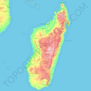
Name: Madagascar topographic map, elevation, terrain.
Location: Madagascar (-25.78402 42.96801 -11.73289 50.67273)
Average elevation: 139 m
Minimum elevation: -1 m
Maximum elevation: 2,568 m
Make a donation
Other topographic maps
Click on a map to view its topography, its elevation and its terrain.
Abuja
Nigeria > Federal Capital Territory > Municipal Area Council
The elevation is 360 metres (1,180 ft).
Average elevation: 508 m
Make a donation
Make a donation
Jos Plateau
Nigeria > Plateau State > Jos East
It covers 8600 km2 and is bounded by 300–600 m escarpments around much of its boundary. With an average altitude of 1,280 m, it is the largest area over 1,000m in Nigeria, with a high point of 1,776m, in the Shere Hills. Several rivers have their sources on the plateau. The Kaduna River drains the western…
Average elevation: 951 m
Make a donation
Make a donation
Galadimawa Village
Nigeria > Federal Capital Territory > Municipal Area Council
Average elevation: 446 m
Make a donation
Make a donation
Make a donation
Make a donation
Make a donation
Make a donation
Make a donation
Make a donation
Make a donation
Make a donation
Make a donation
Make a donation
Make a donation
Make a donation
Jos
Nigeria > Plateau State > Jos North
At an altitude of 1,217 m (3,993 ft) above sea level, Jos' climate is closer to temperate than that of the vast majority of Nigeria. Average monthly temperatures range from 21–25 °C (70–77 °F), and from mid-November to late January, night-time temperatures drop as low as 7 °C (45 °F). Hail sometimes…
Average elevation: 1,181 m
Make a donation
Make a donation
Make a donation
Make a donation
Make a donation
Make a donation
Make a donation