
Make a donation
Moldova topographic map
Click on the map to display elevation.
Make a donation
Moldova
While most of the country is hilly, elevations never exceed 430 m (1,411 ft), the highest point being the Bălănești Hill. Moldova's hills are part of the Moldavian Plateau, which geologically originate from the Carpathian Mountains. Its subdivisions in Moldova include the Dniester Hills (Northern Moldavian Hills and Dniester Ridge), the Moldavian Plain (Middle Prut Valley and Bălți Steppe), and the Central Moldavian Plateau (Ciuluc-Soloneț Hills, Cornești Hills—Codri Massive, "Codri" meaning "forests"—Lower Dniester Hills, Lower Prut Valley, and Tigheci Hills). In the south, the country has a small flatland, the Bugeac Plain. The territory of Moldova east of the river Dniester is split between parts of the Podolian Plateau, and parts of the Eurasian Steppe. Moldova's exceptionally rich Chernozem soil covers around three-quarters of the country's land area.
Make a donation
About this map
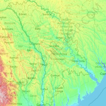
Name: Moldova topographic map, elevation, terrain.
Location: Moldova (45.46721 26.61641 48.49205 30.16371)
Average elevation: 171 m
Minimum elevation: -8 m
Maximum elevation: 1,712 m
Make a donation
Other topographic maps
Click on a map to view its topography, its elevation and its terrain.
Make a donation
Make a donation
Abuja
Nigeria > Federal Capital Territory > Municipal Area Council
The elevation is 360 metres (1,180 ft).
Average elevation: 508 m
Make a donation
Jos Plateau
Nigeria > Plateau State > Jos East
It covers 8600 km2 and is bounded by 300–600 m escarpments around much of its boundary. With an average altitude of 1,280 m, it is the largest area over 1,000m in Nigeria, with a high point of 1,776m, in the Shere Hills. Several rivers have their sources on the plateau. The Kaduna River drains the western…
Average elevation: 951 m
Galadimawa Village
Nigeria > Federal Capital Territory > Municipal Area Council
Average elevation: 446 m
Make a donation
Make a donation
Make a donation
Make a donation
Make a donation
Make a donation
Make a donation
Make a donation
Make a donation
Make a donation
Make a donation
Make a donation
Make a donation
Make a donation
Make a donation
Jos
Nigeria > Plateau State > Jos North
At an altitude of 1,217 m (3,993 ft) above sea level, Jos' climate is closer to temperate than that of the vast majority of Nigeria. Average monthly temperatures range from 21–25 °C (70–77 °F), and from mid-November to late January, night-time temperatures drop as low as 7 °C (45 °F). Hail sometimes…
Average elevation: 1,181 m
Make a donation
Make a donation
Make a donation
Make a donation
Make a donation
Make a donation
Make a donation