
Make a donation
Laos topographic map
Click on the map to display elevation.
Make a donation
Laos
The people of Laos are often categorised by their distribution by elevation: (lowlands, midlands and upper high lands) as this somewhat correlates with ethnic groupings. More than half of the nation's population is ethnic Lao—the principal lowland inhabitants, and the politically and culturally dominant people of Laos. The Lao belong to the Tai linguistic group who began migrating south from China in the first millennium CE. Ten per cent belong to other "lowland" groups, which together with the Lao people make up the Lao Loum (lowland people).
Make a donation
About this map
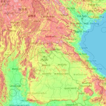
Name: Laos topographic map, elevation, terrain.
Location: Laos (13.90968 100.08432 22.50867 107.63500)
Average elevation: 432 m
Minimum elevation: -1 m
Maximum elevation: 2,808 m
Make a donation
Other topographic maps
Click on a map to view its topography, its elevation and its terrain.
Make a donation
Galadimawa Village
Nigeria > Federal Capital Territory > Municipal Area Council
Average elevation: 446 m
Make a donation
Make a donation
Make a donation
Make a donation
Make a donation
Make a donation
Make a donation
Make a donation
Make a donation
Make a donation
Make a donation
Make a donation
Make a donation
Make a donation
Make a donation
Jos
Nigeria > Plateau State > Jos North
At an altitude of 1,217 m (3,993 ft) above sea level, Jos' climate is closer to temperate than that of the vast majority of Nigeria. Average monthly temperatures range from 21–25 °C (70–77 °F), and from mid-November to late January, night-time temperatures drop as low as 7 °C (45 °F). Hail sometimes…
Average elevation: 1,181 m
Make a donation
Make a donation
Make a donation
Make a donation
Make a donation
Make a donation
Make a donation
Make a donation
Make a donation