
Kwara State topographic map
Interactive map
Click on the map to display elevation.
Kwara State
Located at an elevation of 286.86 meters (941.14 feet) above sea level, Kwara has a Tropical wet and dry or savanna climate (Classification: Aw). The city's yearly temperature is 29.54 °C (85.17 °F) and it is 0.08% higher than Nigeria's averages. Kwara typically receives about 101.45 millimeters (3.99 inches) of precipitation and has 148.38 rainy days (40.65% of the time) annually. It is located at 4.3874051 longitude and 8.9668961 latitude.
About this map
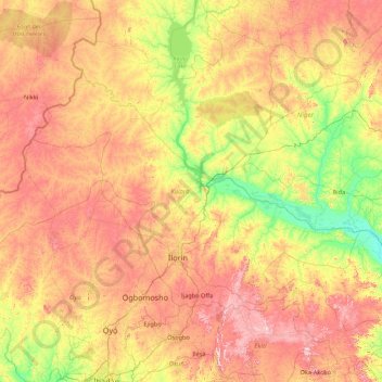
Name: Kwara State topographic map, elevation, terrain.
Location: Kwara State, Nigeria (8.00767 2.72931 10.16833 6.20854)
Average elevation: 283 m
Minimum elevation: 46 m
Maximum elevation: 736 m
Other topographic maps
Click on a map to view its topography, its elevation and its terrain.
Auchi
Nigeria > Edo State > Etsako West
The climate at Auchi, which has an elevation of 0 meters (None feet) above sea level, is tropical wet and dry or savanna (Aw classification). The district's average annual temperature is -0.74% lower than Nigeria's averages at 28.72 °C (83.7 °F). 183.14 millimeters (7.21 inches) of precipitation and 265.4…
Average elevation: 186 m
Omu Aran
Nigeria > Kwara State > Irepodun
Omu Aran has a tropical wet and dry or savanna climate and is located at an elevation of 536.14 meters (1758.99 feet) above sea level (Classification: Aw). The district's average annual temperature is 0.26% higher than Nigeria's averages at 29.72°C (85.5°F). Omu Aran generally has 149.31 wet days per year…
Average elevation: 539 m