
Rivers State topographic map
Interactive map
Click on the map to display elevation.
Rivers State
Rivers State is a predominantly low-lying pluvial state in southern Nigeria, located in the eastern part of the Niger Delta on the oceanward extension of the Benue Trough. The inland part of the state consists of tropical rainforest, and towards the coast, the typical Niger Delta environment features many mangrove swamps. Rivers State has a total area of 11,077 km2 (4,277 sq mi), making it the 26th largest state in Nigeria. Surrounding states are Imo, Abia and Anambra to the north, Akwa Ibom to the east and Bayelsa, Delta to the west. On the south, it is bounded by the Atlantic Ocean. Its topography ranges from flat plains, with a network of rivers to tributaries.
About this map
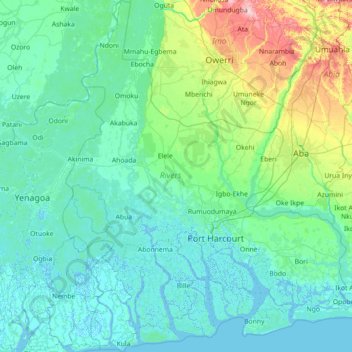
Name: Rivers State topographic map, elevation, terrain.
Location: Rivers State, Nigeria (4.30796 6.39839 5.73029 7.60408)
Average elevation: 29 m
Minimum elevation: -4 m
Maximum elevation: 247 m
Other topographic maps
Click on a map to view its topography, its elevation and its terrain.
Omu Aran
Nigeria > Kwara State > Irepodun
Omu Aran has a tropical wet and dry or savanna climate and is located at an elevation of 536.14 meters (1758.99 feet) above sea level (Classification: Aw). The district's average annual temperature is 0.26% higher than Nigeria's averages at 29.72°C (85.5°F). Omu Aran generally has 149.31 wet days per year…
Average elevation: 539 m