
Ondo State topographic map
Interactive map
Click on the map to display elevation.
Ondo State
Nicknamed the "Sunshine State", Ondo State is the 19th most populated state in the country, and the 25th-largest state by landmass. The state is predominantly Yoruba, and the Yoruba language is commonly spoken. The state economy is dominated by the petroleum industry. Cocoa production, asphalt mining, and activities related to the state's extensive coastline also are part of the economy. It is the home to the Idanre inselberg hills, playing host to the highest geographical point in the western half of Nigeria at higher than 1,000 Meters in elevation.
About this map
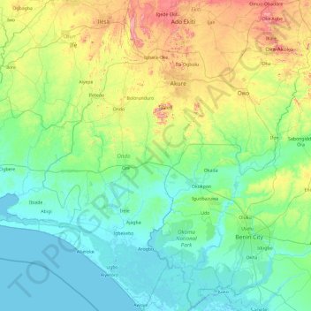
Name: Ondo State topographic map, elevation, terrain.
Location: Ondo State, Nigeria (5.88740 4.37612 7.75025 6.00420)
Average elevation: 154 m
Minimum elevation: -2 m
Maximum elevation: 873 m
Other topographic maps
Click on a map to view its topography, its elevation and its terrain.
Omu Aran
Nigeria > Kwara State > Irepodun
Omu Aran has a tropical wet and dry or savanna climate and is located at an elevation of 536.14 meters (1758.99 feet) above sea level (Classification: Aw). The district's average annual temperature is 0.26% higher than Nigeria's averages at 29.72°C (85.5°F). Omu Aran generally has 149.31 wet days per year…
Average elevation: 539 m