
Make a donation
Osun State topographic map
Click on the map to display elevation.
Make a donation
Osun State
The climate of Osun is tropical savanna usually warm, with a wet and dry season. It has a yearly average temperature of 64 °F and receives approximately 596 inches of rainfall. It is dry for 59 days throughout the year, with an average moisture in the air of 77% and a UV index of 7. Located at an elevation of 266.33 meters (873.79 feet) above sea level, Osun has a Tropical wet and dry or savanna climate (Classification: Aw). The city's yearly temperature is 28.35 °C (83.03 °F) and it is -1.11% lower than Nigeria's averages. Osun typically receives about 127.75 millimeters (5.03 inches) of precipitation and has 237.62 rainy days (65.1% of the time) annually. It is located at 4.5199593 longitude and 7.5628964 latitude.
Make a donation
About this map
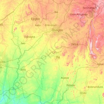
Name: Osun State topographic map, elevation, terrain.
Location: Osun State, Nigeria (6.98073 4.05293 8.09550 5.05763)
Average elevation: 285 m
Minimum elevation: 51 m
Maximum elevation: 745 m
Make a donation
Other topographic maps
Click on a map to view its topography, its elevation and its terrain.
Make a donation
Make a donation
Make a donation
Make a donation
Make a donation
Make a donation
Make a donation
Make a donation
Make a donation
Make a donation
Make a donation
Make a donation
Make a donation
Make a donation
Omu Aran
Nigeria > Kwara State > Irepodun
Omu Aran has a tropical wet and dry or savanna climate and is located at an elevation of 536.14 meters (1758.99 feet) above sea level (Classification: Aw). The district's average annual temperature is 0.26% higher than Nigeria's averages at 29.72°C (85.5°F). Omu Aran generally has 149.31 wet days per year…
Average elevation: 539 m
Make a donation
Make a donation
Make a donation
Make a donation
Make a donation
Make a donation
Make a donation
Make a donation
Ibadan
Nigeria > Oyo State > Ibadan South West
Ibadan, coined from the phrase "Eba Odan", which literally means 'by the edge of the meadow', came into existence in 1829, during a period of turmoil that characterized Yorubaland at the time. It was in this period that many old Yoruba cities such as old Oyo (Oyo ile), Ijaye and Owu disappeared, and newer ones…
Average elevation: 191 m
Make a donation
Make a donation
Make a donation